
SDG11: Sustainable Cities and Communities
Share of open public space area in cities in China(2020)
Target: 11.7 By 2030, provide universal access to safe, inclusive and accessible, green and public spaces, in particular for women and children, older persons and persons with disabilities.
| Highlights |
| The share of open public space area in built-up areas in Chinese provinces (excluding Hong Kong, Macao and Taiwan province) averaged 19.50% in 2018, 1.5 percentage points higher than 17.98% in 2015. |
Background
The monitoring and evaluation of urban open public space is helpful to promoting urban space transformation, quality upgrading, and sustainable development. The public space as defined in SDG 11.7.1 mainly includes public green space and urban roads. The former can improve people's wellbeing and health, while the latter is a direct indicator of urban prosperity. UN-HABITAT is responsible for SDG11.7 evaluation globally. The Atlas of Urban Expansion, that analyzes 95 406 km2 of built-up areas in selected cities around the world, finds that 59% of them are occupied by urban public spaces, and nearly half are urban roads. According to China's Progress Report on Implemention of the 2030 Agenda for Sustainable Development (2019), by 2018, a total of 56 000 km of greenways had been built, and the urban living environment greatly improved. There is, however, no national monitoring and evaluation result of this indicator. This report adopted the design and method of UN SDGs to evaluate China's progress in SDG 11.7.1 and compared the results of 2015 and 2018.
Data used
①SDG 11.7.1 Evaluation Result, 2015 (Guo et al., 2019).
②Land cover data for China, 2018.
③Navigation vector data of cities in China, 2018.
④Statistical yearbook of prefectural-level cities in China.
Method
The "urban land" subcategory was extracted from the land cover data to establish the built-up area, and the public space data (green space, square and roads) was extracted from the navigation vector data. The evaluation process was as follows: (1) Define a Generate Fishnet function, and use the grid transformation method to generate national kilometer grid; (2) Overlay the national grid with the spatial data of green space and square to generate the grid spatial data; (3) Convert highways, provincial roads, county roads, township roads and other urban roads into polygon data by their width, and overlay with the national grid to generate kilometer grid road spatial data; (4) Integrate road data and public green space data at the grid scale and divide by the total urban built-up area to obtain the share of open public space area; (5) Convert the share from the kilometer grid scale to the county, municipal, provincial and national scales through spatial statistical analysis.
Results and analysis
The evaluation of open public space in prefectural-level Chinese cities in 2018 revealed the following. At the municipal scale, the share of open public space in nearly 50 cities exceeded 20%. Beijing, Shenzhen and Xiamen had the largest share, exceeding 30%, with urban roads taking up more than 25%. From the perspective of spatial pattern (Fig. 1), the share of open public space area of cities on the southeast side of the Hu Line was generally larger than that on the northwest side, reflecting significant regional differences. From the perspective of urban agglomerations, the scale of open public space area in the city clusters in the Beijing-Tianjin-Hebei region, Yangtze River Delta, Pearl River Delta, Sichuan basin and central Yunnan was generally larger than in their surrounding regions, demonstrating a clear feature of spatial agglomeration.
The share of open public space in built-up areas in Chinese provinces (excluding Hong Kong, Macao and Taiwan province) averaged 19.50% in 2018, 1.5 percentage points higher than 17.98% in 2015. Guangdong and Beijing had the largest share of 28.60%, while Guangxi had the smallest share of 11.16%. From 2015 to 2018, the share of open public space in all provinces increased slightly except for Beijing, Chongqing, Sichuan, Fujian and Hubei (Fig. 2). Both urban built-up areas and open public space mainly including squares, parks and roads increased. The increase in open public space outpaced urbanization, which began to slow down, reflecting the growing attention China pays to the planning and improvement of open public space in urban development.
The share of open public space area increased with the expansion of cities, and the scale of open public space in super-large cities was larger than that in smaller cities. It was also in sync with economic development, being larger in more advanced cities. Level of economic development, living standards, urbanization rate and population size were all factors having a strong influence on the scale of open public space.
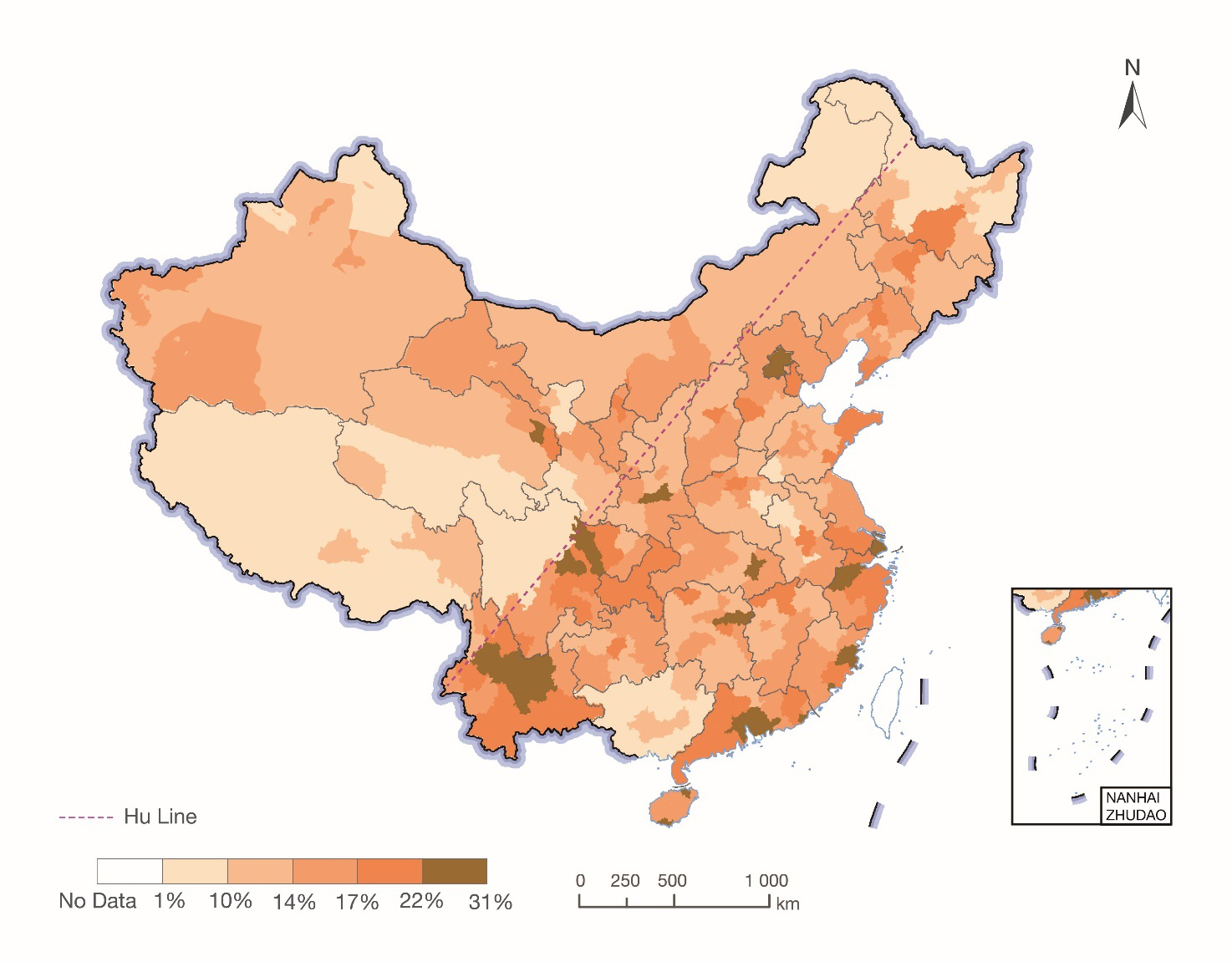
Figure 1. Share of open public space area in prefectural-level Chinese cities in 2018
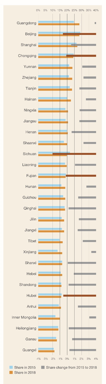
Figure 2. Changes in the share of open public space at provincial scale in China
Outlook
This case study evaluated and compared urban open public space, as defined by SDG 11.7, in China in 2015 and 2018 by using navigation and land cover data, and found that the method it adopted to monitor changes in Chinese cities concerning SDG 11.7.1 was easy to apply and data access was not difficult.
This method is a solution to the evaluation of SDG 11.7.1, but it cannot yet be applied to evaluating open public space categorized by gender, age or people with disabilities. Future work needs to be done to address this method's sensitivity to the definition of urban built-up area and data accuracy, and the minor errors in the data of built-up area, extracted from "urban land" subcategory.