
SDG11: Sustainable Cities and Communities
Impact assessment of storm surge inundation in Shenzhen(2020)
Target: 11.5 By 2030, significantly reduce the number of deaths and the number of people affected and substantially decrease the direct economic losses relative to global gross domestic product caused by disasters, including water-related disasters, with a focus on protecting the poor and people in vulnerable situations.
| Highlights |
| Typhoons Nida and Mangkhut that hit Shenzhen in 2016 and 2018, respectively, were simulated and urban floodwater depth data were obtained with an average accuracy of 90.68%. A storm-surge digital-twin assessment system was established to assess the number of people affected/injured/killed by and direct economic losses from storm surge hazards in Shenzhen. For Dapeng new district, Bao'an district, Nanshan district, and Futian district, which suffered severe seawater influx, additional flood-control dikes should be built along the coast and be reinforced with sandbags prior to a storm surge. |
Background
Storm surge hazards have become one of the most serious natural disasters, inflicting increasing losses and posing a challenge to social and economic sustainability in Shenzhen and other coastal cities, where there is a great density of both population and economic activities. Currently, three problems hinder the assessment of direct economic losses and the number of people affected: (1) a lack of high-resolution historical data; (2) an over-reliance on statistical data in traditional methods; and (3) a multitude of influencing factors. A storm-surge digital-twin method, based on Big Earth Data, can quickly evaluate the direct economic losses and people affected in Shenzhen by combining the numerical simulation model and expert empirical model. It can provide vital support for decision-making on targeted disaster prevention.
Data used
①The US National Oceanic and Atmospheric Administration's (NOAA) Global Self-consistent, Hierarchical, High-resolution Geography Database (GSHHGD).
②The US National Aeronautics and Space Administration's (NASA) 1/8-degree Cross-Calibrated Multi-Platform (CCMP) Wind Vector Analysis Product.
③NOAA's 1/60-degree global relief model of Earth's surface that integrates land topography and ocean bathymetry.
④Oregon State University's 1/30-degree harmonic constants.
⑤Ten-meter resolution national land classification data in 2018 (Gong et al., 2019).
⑥OpenStreetMap's administrative boundary dataset.
⑦ The China Meteorological Administration's typhoon dataset.
⑧WorldPop's 100-meter resolution population count dataset.
⑨The Construction Cost Index and Shenzhen Statistical Yearbook.
⑩ Tidal data from the tide-gauge stations in Shekou Port and Yantian Port, Guangdong.
Method
Focusing on SDG 11.5 indicators of direct economic losses, affected people, and deaths, the evaluation method was established as follows. First, the Finite Volume Community Ocean Model (FVCOM), an unstructured-grid based finite-volume ocean numerical simulation model, was utilized to calculate the depth of floodwater, to overcome the lack of historical data. Second, the economic loss-assessment model, proposed by the National Natural Hazard Comprehensive Research Group, was utilized to quantitatively estimate the total direct economic losses by evaluating the damage rate and unit value for each affected construction. Finally, the flood risks to people methodology, proposed by the British Hydraulic Research Institute, was adopted to establish the relationships between the people affected and the urban floodwater characteristics, urban characteristics, and population characteristics to quantitatively evaluate deaths and the number of people affected.
Results and analysis
Typhoons Nida and Mangkhut hit Guangdong province on August 2, 2016 and September 16, 2018, respectively. Their storm surges were simulated to calculate the water depths, which were 87.86% and 93.51% accurate, respectively, with an average accuracy rate of 90.68% when compared with the tide level data recorded by the Shekou and Yantian tide gauge stations (113°53′E, 22°28′N and 114°16′E, 22°35′N).
Figure 1 shows the simulated direct economic losses from Nida were 367 900 and from Mangkhut 265 million yuan. According to statistics of the Guangdong Provincial Oceanic and Fishery Department, the direct economic losses from Nida were 360 000 yuan and the statistics of the Guangdong Provincial Department of Natural Resources put the direct economic losses from Mangkhut at 255 million yuan, pointing to a high accuracy of the simulation results.
Figure 2 shows the assessment results of the affected population. The simulated results were: for Nida, 18 600 affected, 24 injured, and no death; for Mangkhut, 28 100 affected, 41 injured and no death. The statistics published by the Guangdong Provincial Oceanic and Fishery Department showed Nida affected 18 300 people and caused no death in Shenzhen, while the statistics of the Ministry of Emergency Management of China were that Mangkhut caused a total of five deaths in the five provinces of Guangdong, Guangxi, Hainan, Hunan and Guizhou and no death in Shenzhen. The simulated results were accurate.
Most of the direct economic losses and affected people were in Bao'an district, Nanshan district and Futian district, due to their geographical proximity to the sea and flat terrain. Dapeng new district also suffered the influx of seawater, but did not incur too much loss thanks to its mountainous terrain. To reduce future losses, the flood-control dikes should be reinforced and sandbags should be made available in Bao'an, Nanshan and Futian districts.
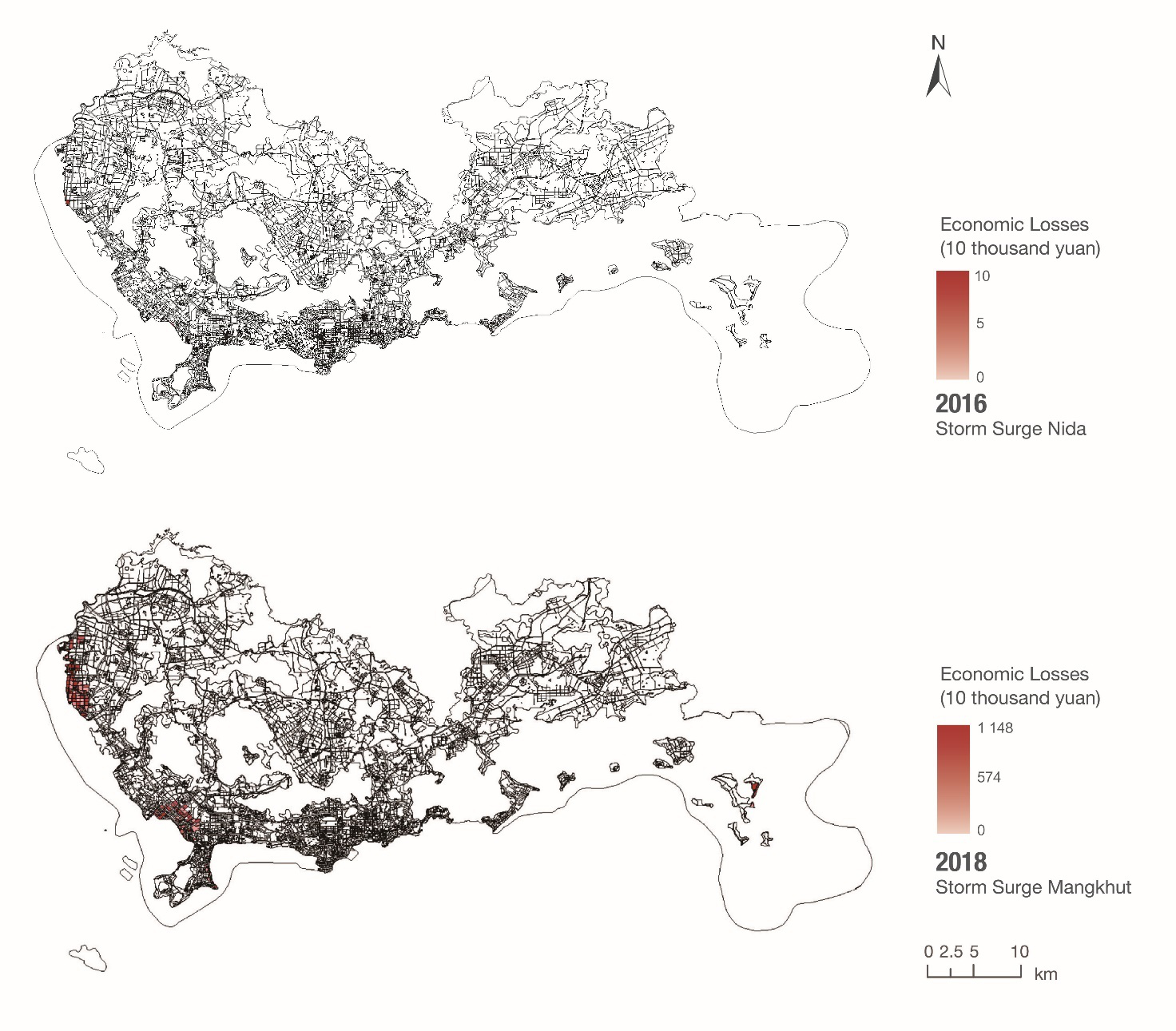
Figure 1. The direct economic loss assessments of Nida in 2016 and Mangkhut in 2018 based on the economic loss-assessment model
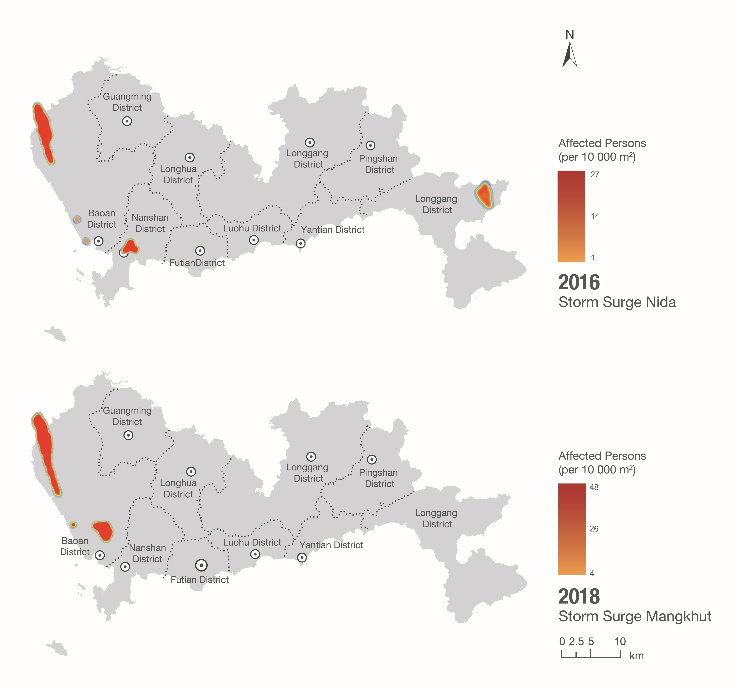
Figure 2. The distribution of people affected by Nida in 2016 and Mangkhut in 2018 based on the flood risks to people methodology
Outlook
In light of indicators SDG 11.5.1 and 11.5.2, this case study assessed the direct economic losses, people affected and injured and deaths in Shenzhen caused by storm surge hazards—Nida in 2016 and Mangkhut in 2018, using a storm-surge digital-twin assessment method. The case can provide vital support to decision-making on storm surge hazard prevention in Shenzhen.
For more comprehensive disaster-prevention decision support, future work should: (1) simulate more storm surge hazards that posed a serious threat to Shenzhen; and (2) simulate storm surge hazards of different intensities in Shenzhen and evaluate the direct economic losses and the number of people affected, with the purpose of giving early warning to the disaster-prone areas and informing decision-making.