
Processes of aeolian desertification in the semi-arid region and its peripheries in northern China and review of control outcomes(2020)
| Highlights |
|
Long-time-series datasets on the aeolian desertification in northern China from 1975 to 2015 are developed, providing important data support for accurately understanding the spatiotemporal processes of aeolian desertification in China. The year 2000 was a watershed in the aeolian desertification of China's semi-arid regions. Until 2000, there had been a degradation trend primarily because of irresponsible human activities such as overlogging, overcultivation and overgrazing. The aeolian desertification process began to reverse in 2000, largely thanks to the implementation of ecological protection policies.
|
Background
Aeolian desertification is a type of desertification induced by the actions of wind-blown sand (Wang et al., 2015). It occurs and develops mainly in the semi-arid agro-pastoral ecotones and pastoral zones of northern China, which are also the main areas where the reversal of aeolian desertification has taken place in recent years. To monitor the trends of aeolian desertification in those areas and analyze how spatiotemporal changes in the aeolian desertified land respond to climate variation and anthropogenic factors is of vital importance, because the findings can help identify how aeolian desertification occurs and evolves and predict its future trajectory, so that policy-makers can develop appropriate control measures informed by science.
Data used
① US Landsat time series data from 1975 to 2015.
② 1:100 000 scale topographic maps.
③ 1:1 000 000 topographic maps, Ministry of Natural Resources.
Method
Aeolian desertification information was extracted in compliance with the aeolian desertification classification system and interpretation keys. The classification system used in this study comes from the Classification System for Remote Sensing Monitoring of Aeolian Desertification in Northern China. The latter classifies aeolian desertification into four types: shifting, semi-shifting, semi-fixed and fixed sands. They correspond to four levels of severity of aeolian desertification: extremely severe, severe, moderate and light (Wang et al., 2004).
Results and analysis
Figure 1 shows the distribution of aeolian desertified areas in the semi-arid areas and their peripheries in northern China. Aeolian desertification within the monitored region is most prominent in five sandy lands, where aeolian desertification accelerated between 1975 and 2000 with an average growth rate of approximately 2 486.57 km2 per annum. From 2000 onward, the aeolian desertification process began to slow down and the area of aeolian desertified land began to shrink gradually, with an average reduction of 578.35 km2 per annum, much slower than the expansion prior to 2000. The rate of reversal since 2000 has varied between different periods: The reversal was quite fast between 2000 and 2005, at an average reduction rate of 1 129.05 km2 per annum. It went down to 604.81 km2 per annum between 2005 and 2010. Then, from 2010 to 2015, the area of aeolian desertified land remained practically unchanged, down by a mere 5.96 km2 in a space of five years.
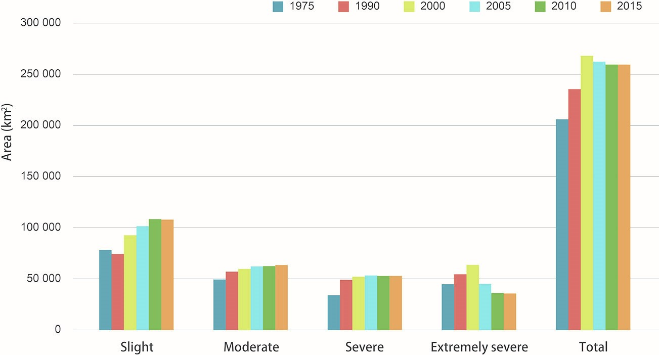
Spatiotemporal changes varied among different types of aeolian desertified land (Fig. 2). Slightly and moderately aeolian desertified areas accounted for approximately 62% of the total area, while severely and extremely severely aeolian desertified areas accounted for approximately 38% of the total. The area of slightly aeolian desertified land increased in all periods except 1975-1990 when it decreased, and the increase was particularly significant in the post-2000 period, indicating that the intensity of aeolian desertification in the monitored region was easing. The trends of moderately and severely aeolian desertified areas were rather similar: They increased significantly between 1975 and 1990, before easing off and then stabilizing gradually after 2000. The area of extremely severe desertification changed drastically over time: a sharp increase prior to 2000, followed by a swift drop. This pattern is further proof of a general trend of reversal, i.e. a lessening in the intensity of aeolian desertification in tandem with the decreasing area of aeolian desertification in the semi-arid areas of northern China after 2000.

Aeolian desertification in the semi-arid areas and their peripheries in northern China is a result of the fragilities and volatilities of the local ecosystems and, to a larger extent, of anthropogenic causes. In the past 40 years, the natural environment context has not changed significantly. During the same period, however, there have been significant changes in climate and human activities. For a start, in the context of precipitation unchanged in the region as a whole and reduced precipitation in isolated areas, the main sign of climate change is a higher incidence of heavy rainfall coupled with a lower frequency of precipitation in general. This pattern has been particularly pronounced since 2010. Secondly, human activities have gradually transitioned from overcultivation, overgrazing and overlogging prior to 2000 to reforestation and regrassing of farmland, grazing ban by fencing off pastures and rotation grazing with rest periods, which are more sustainable ways of using land with environmental protection in mind. The variations of climatic and human behavior in different periods subjected aeolian desertification to the action of different drivers in those periods. Studies indicate that the occurrence and expansion of aeolian desertification from 1975 to 2000 was largely a result of irrational human activities. The reversal of desertification from 2000 to 2010 is primarily attributable to the implementation of environmental protection policies. This reversal process slowed down from 2010 to 2015, largely because of droughts.