
Dynamics between large-scale greening and soil and water conservation on the Loess Plateau and sedimentation of the Yellow River(2020)
| Highlights |
| Big Earth Data feeds into the calculation of the Soil Erosion Control Index (SECI) of different periods to quantify the effect of vegetation change on soil and water conservation . Since 2000, vegetation coverage on the Loess Plateau has been greatly improved, with an average increase of 17.06%, improving its effect on soil and water conservation by 22.00%. |
Background
Since 2000, thanks to the reversion of farmland to forest and grass as well as other soil erosion control measures, the ecological environment of China's Loess Plateau has undergone a profound transformation, with large-scale, significant improvements in its vegetation. As one of the few regions in the world where vegetation has markedly improved in recent years, it has attracted much international attention. With significant increases in vegetation comes a significant improvement in soil erosion on the Loess Plateau, as well as considerably reduced sedimentation in the Yellow River. Centering on SDG Target 15.3 of the UN 2030 Agenda, this study is designed to gauge the contribution of large-scale greening of the Loess Plateau over the past two decades to soil and water conservation by calculating the Soil Erosion Control Index (SECI) of chosen periods to track the effects of changed vegetation on erosion control, on the basis of remotely sensed data and Fraction of Vegetation Cover (FVC). The purpose is to explore and develop a new approach to investigate regional land degradation and monitor soil erosion control in the future.
Data used
① Fraction of Vegetation Cover (FVC) product from 2000 to 2019 at 1 000 m resolution, Global Land Service.
② Water Resources Bulletin, Yellow River Conservancy Commission.
③ Yellow River Sediment Bulletin, Yellow River Conservancy Commission.
Method
Using the FVC dynamic data of the Loess Plateau between 2000 and 2019, SECI is calculated as a measure of the ability of soil and water conservation strategies to control soil erosion (which may be construed as the effect of vegetation on erosion control if the measures taken are specific to vegetation only), to work out the erosion control effect of large-scale vegetation restoration projects (including reforestation of farmland, grazing ban and afforestation) on the Loess Plateau in recent years, by investigating the effect of changed vegetation on erosion control using the Universal Soil Loss Equation (USLE).
Results and analysis
Over the past 20 years, the vegetation cover of the Loess Plateau has increased substantially (Fig. 1a), with an average increase of 17.06% across the region. Further studies indicate that the rate of vegetation increase varies among different areas and typical river basins: 16.06% in the Shaanxi part of the Loess Plateau, 21.58% in Yan'an City, 23.89% in north of Ganguyi along the Yanhe River, and 27.10% along the Dali River in northern Shaanxi.
The two-decade SECI increments for the Loess Plateau are shown in Figure 1b, indicating a correlation between the SECI and vegetation cover. The SECI registered an average increase of 22.00% for the entire Loess Plateau: 17.10% in the Shaanxi part of the Yellow River basin, 29.90% along the Dali River in northern Shaanxi, 12.30% in Yan'an City, and 18.10% in the upper reaches of the Yanhe River (north of Ganguyi).
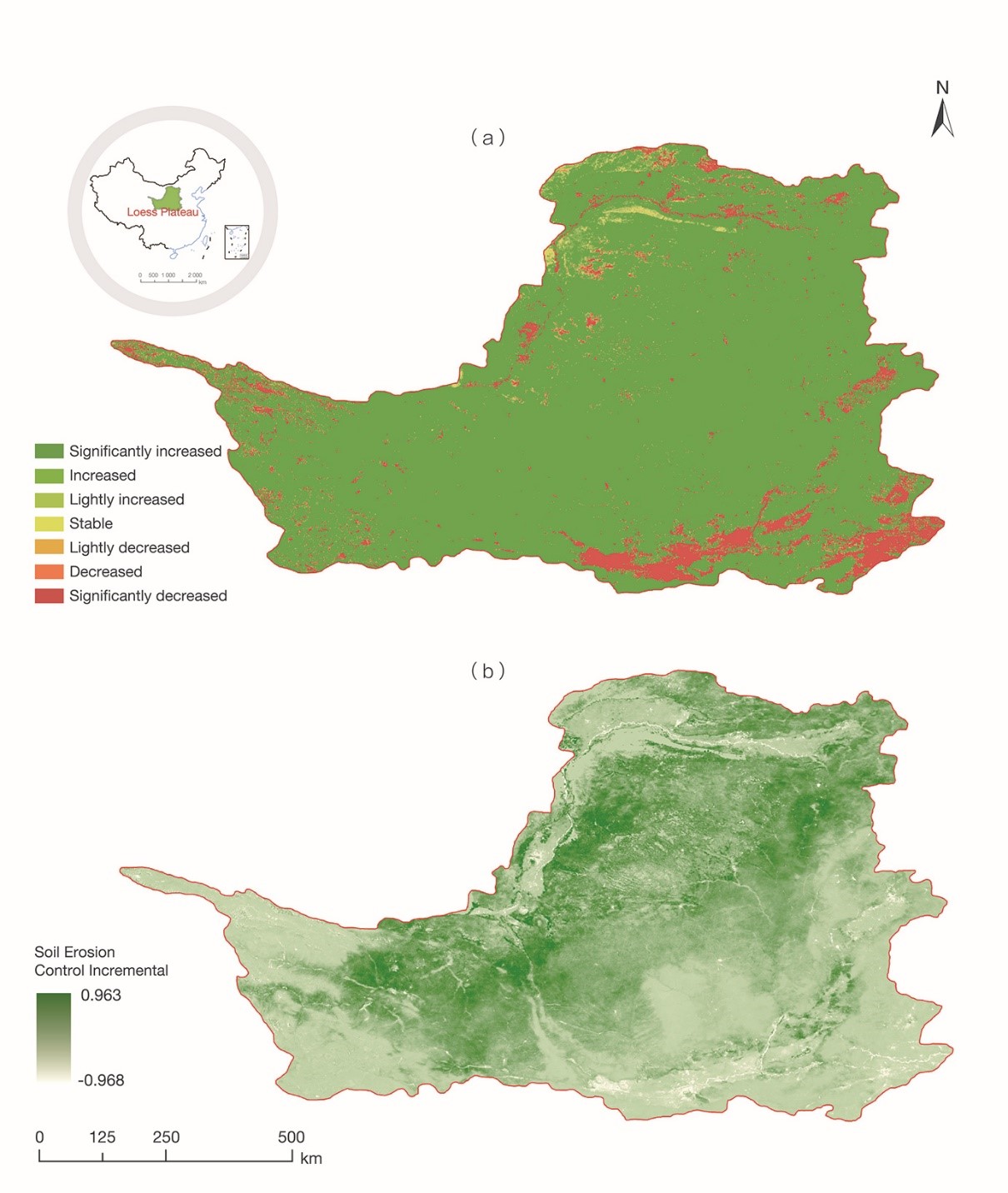
For the purposes of this study, a Big Earth Data-based SECI was created to quantify the contribution of changed vegetation to soil erosion control. The findings indicate that the much improved vegetation cover of the Loess Plateau over the past 20 years has had a significant effect on soil and water conservation in the region, albeit to varying degrees from area to area.
Since the end of the 20th century, large-scale, intensive soil and water conservation projects for the Loess Plateau have been under way. During this period, the annual sediment discharge between Hekou and Longmen has been clearly responding to the human effort to reduce sedimentation, maintaining a low level of sediment discharge year after year. Since 2000, the annual sediment discharge at the Tongguan Hydrological Station of the Yellow River has been kept under 3.00×10⁸ t, which is proof, at the receiving end, of the effectiveness of soil and water conservation on the Loess Plateau in recent years and that of the large-scale restoration of vegetation on the Plateau in stemming soil erosion.