
Spatiotemporal distribution of forest types in China's Yangtze River basin(2020)
| Highlights |
| A remote sensing classification framework for identifying forest types is proposed, using multi-rule time-series imagery composition and combining spatial-temporal-spectral features with machine learning algorithm. A forest type distribution map in 2018 was produced covering Yangtze River basin in China with 10 m spatial resolution and an overall accuracy of 83.25%. |
Background
① Landsat time-series images at 30 m spatial resolution from 1985 to 2018.
② Sentinel-2 time-series images at 10 m spatial resolution from 2015 to 2019.
③ A 30 m spatial resolution Digital Elevation Model of the Yangtze River basin.
④ Yangtze River basin boundary data.
⑤ Data from field surveys conducted in 2014, 2015 and 2018.
Method
In view of the demand that mapping of cloud cover and large-scale land cover has on high-quality remotely sensed images, a multi-rule multi-spectral time-series remote sensing image composition method was proposed in this case. Using the pixels of remotely sensed images covering the same area over the same time periods, high-quality cloudless remotely sensed images were composited for the area under study. Taking advantage of the high spatial resolution and higher spectral resolution of Sentinel-2 images and the long-time series Landsat data, spectral-spatial-temporal feature datasets for forest type classification were established (Cheng et al., 2019). Then, a forest type map at 10 m spatial resolution covering China's Yangtze River basin 2018 was acquired using machine learning algorithm based on cloud computing platform.
Results and analysis
The spatial distribution of forest types in the Yangtze River basin is shown in Figure 1. The survey by type indicates that forests in the Yangtze River basin are dominated by evergreen coniferous, mixed and evergreen broadleaved species. Evergreen conifers are concentrated around the upper reaches of the Yangtze and are common in such areas as Tongtian River, Yalong River and Jinsha River, accounting for approximately 15.76% of the total area; mixed forests are concentrated in the north–central part of the Yangtze River basin, found mainly in the eastern Hengduan Mountains and north of Qinling Mountains, accounting for 14.15% of the total area; evergreen broadleaved forests are concentrated around the Wu River, Liu River and Gan River along the middle to lower reaches of the Yangtze, accounting for approximately 7.29% of the total area. Deciduous broadleaved and deciduous conifers are a minority.
The results were validated against field survey data, and the validation indicated that the overall classification accuracy was 83.25%. The Producer's Accuracy (PA) ranged from 73.08% to 100%. The PA for deciduous needle-leaved forests was the highest, at 100%, with an omission error of 0. The User's Accuracy (UA) ranged from 56.59% to 94.50%. The UA for evergreen broadleaved forests was the highest, at 94.50%, indicating a minimal commission error.
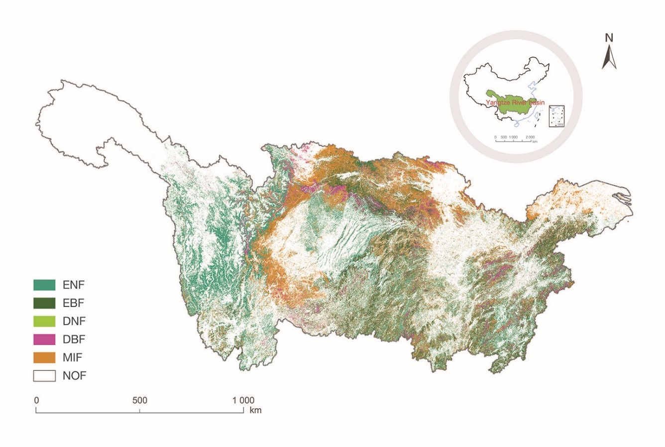
Figure 1. Remotely sensed spatial distribution of forests by type in the Yangtze River basin
(NOF=Non-Forest area; EBF=Evergreen Broadleaved Forest; DBF=Deciduous Broadleaved Forest; ENF=Evergreen Needle-leaved Forest; DNF=Deciduous Needle-leaved Forest; MIF=Mixed Forest)
Outlook
To the best of our knowledge, this was the first study to create a remotely sensed forest type classification product at 10 m spatial resolution for the Yangtze River basin in 2018. Compared with previous data products, this product has a higher spatial resolution and more diverse and in-depth information on forest types, which can provide data support for the sustainable management of forest resources in the Yangtze River basin.
Going forward, it is our intention to extend the proposed method for mapping forest types with remote sensing data to the rest of China and generate a nationwide by-type forest map for 2018 at 10 m spatial resolution. Furthermore, we shall map forest subtypes within China against SDG 15.1.1, to inform the sustainable management of forest resources in China.