
Global/regional forest cover -2019(2020)
Target: 15.1 By 2020, ensure the conservation, restoration and sustainable use of terrestrial and inland freshwater ecosystems and their services, in particular forests, wetlands, mountains and drylands, in line with obligations under international agreements.
| Highlights |
| A remotely sensed global forest cover map for 2019 is independently produced at a spatial resolution of 30 m and an overall accuracy of 86.45%, providing valuable spatial data and effective decision-making support for the assessment of 2030 Agenda implementation progress. In 2019, there were 36.92x10⁸ hm2 of forests worldwide, covering approximately 24.78% of the Earth's total land area. Of all the continents, South America had the highest ratio of forest area to total land area (47.45%) and Oceania, the lowest (12.80%). |
Background
Forests are vital to human development. "Forests and trees make vital contributions to both people and the planet, bolstering livelihoods, providing clean air and water, conserving biodiversity and responding to climate change." (FAO, 2018a). In recent years, an increasing number of countries, organizations and companies have been involved in remote sensing surveys of global forest resources, such as the Global Forest Cover Change and Global Forest Watch. Since 2010, remote sensing data have been used extensively in the Global Forest Resources Assessments (FRAs), released by the Food and Agriculture Organization of the United Nations (FAO) every five to ten years, to analyze the development of forests at regional and global levels and the possible impacts of changes in demographic, economic, institutional, technological and other external factors on forests (FAO, 2006, 2010, 2016). Rapid and accurate access to global forest cover information and accurate knowledge of the status and changes in forest resources are instrumental in enhancing forest management and utilization in response to global changes and achieving sustainable forest development.
Data used
Global Landsat series imagery with 30 m spatial resolution acquired from 1 January 2019 to 31 December 2019.
Method
Forest referred to in this case is as defined in the Global Forest Resources Assessment (2020), namely, "land spanning more than 0.5 hectares with trees higher than 5 meters and a canopy cover of more than 10 percent, or trees able to reach these thresholds in situ. It does not include land that is predominantly under agricultural or urban land use" (FAO, 2018b). Enhanced by machine learning, big data analysis and other state-of-the-art technologies, rapid monitoring of global forest cover with 30 m resolution was conducted based on long-time-series, multi-source satellite remote sensing data. Compared with similar maps that are currently available both in and outside of China, this product is more up to date, has higher temporal and spatial resolution and is more complete in its spatial coverage.
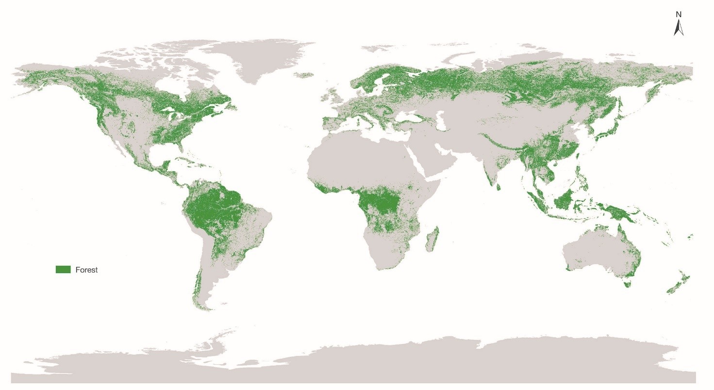
As at the end of 2019, the total area of global forests stood at 36.92×10⁸ hm2, covering approximately 24.78% of the world's total land area (149×108 hm2). The spatial distribution of global forests is as shown in Figure 1. Forests are generally distributed in regions at specific latitudes, mostly in the tropical regions of South America, Central Africa and Southeast Asia, in the boreal regions of Russia and Canada, and along the Pacific coasts and Atlantic coasts.
The world is divided into four climate zones: tropical, subtropical, temperate and arctic. Forest distribution is not even across different zones (Table 2 and Fig. 2). The tropical zone has the largest forest area, accounting for nearly half of the world's total forest area, and 21.91% of the zone is covered by forests, ranking second in the world. This is mainly because the most important forest type, rainforest, is found in this zone. Although the forest area in the arctic zone accounts for approximately a quarter of the world's total only, it has the highest forest cover at 47.27%, largely because of the wide distribution of taiga along the intensely warming mid and high latitudes of the northern hemisphere and concentrated in northern Russia and Canada. Forest area and its percentage of land area in temperate and subtropical zones rank third and fourth respectively.
Table 2 Forest Cover by Climate Zone, 2019
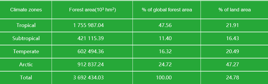
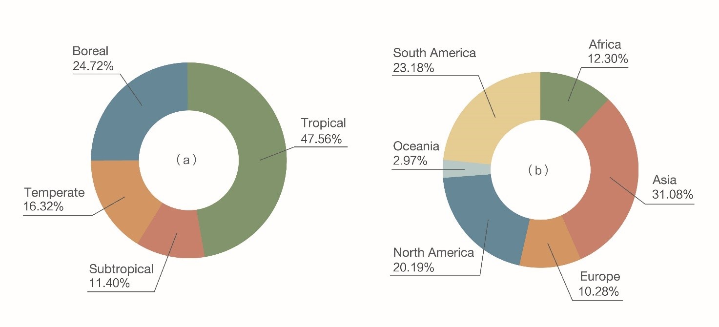
Figure 2. Distribution of forests by climate zone and continent, 2019 (a) By climate zone; (b) By continent
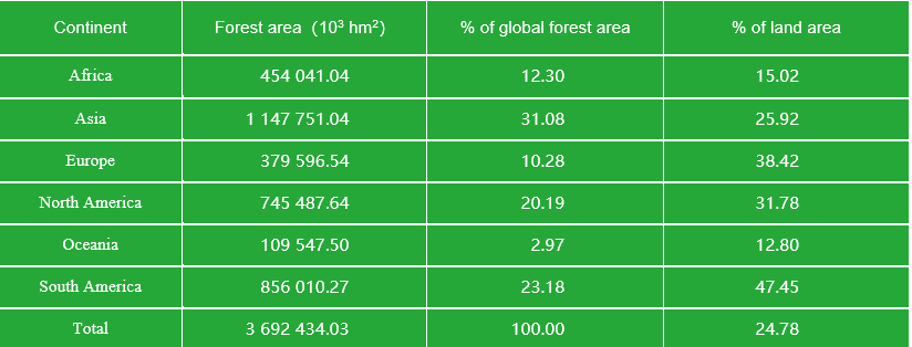
In terms of distribution by continent, forest cover varies significantly among the six continents (Antarctica excluded) (Table 3 and Fig. 2). Asia has the largest land area and the largest forest area, ranking fourth globally in forest cover. South America, although second in the world in terms of forest area, has the highest forest cover at 47.45% and its Amazon basin boasts the world's most extensive and contiguous tropical rainforests. Europe and North America have the second and third highest forest cover respectively. Oceania has the smallest land area, as well as the smallest forest area and forest cover among the six continents.
Table 3 Forest Cover by Continent, 2019
Outlook
Rapid development of global forest cover products is enabled on the basis of long-time-series, multi-source satellite remote sensing data by leveraging machine learning and big data analysis, to monitor implementation against SDG 15.1.1, "forest area as a proportion of total land area", and to compare and analyze the patterns of spatial distribution of forest cover by climate zone and by continent.
Using Big Earth Data, we will be able to release and update remotely sensed global forest cover products in real time. These products can help underresourced and underdeveloped countries and regions monitor changes in their forests, enhance conservation awareness and build greater forest management capacity, to make sustainable development of global forest resources a reality.