
SDG15: Life on Land
Applications of the Mountain Green Cover Index in countries and regions along the Belt and Road(2019)
Scale: Regional
Study area: Belt and Road Region
According to the UNEP World Conservation Monitoring Centre, mountains make up 24% of the world's land area. Mountain areas have a concentrated and rich bioclimatic vertical zone spectrum, which provides important ecological services for maintaining biological diversity. These land features also regulate regional climates and conserve water resources. They are also a source of multiple geological resources and act as an important ecological barrier for social development. The Mountain Green Cover Index is defined as the ratio between green plants located on mountains (e.g., forests, shrubs, woodlands, pastures, farmland) with the total mountain area. This index is used by the International Mountain Science Committee as an important indicator for reflecting the state of environmental protection in mountain areas. The index is also used in the SDG 15 indicator system. Currently, it is generally agreed that there is a direct link between the Mountain Green Cover Index and the health and function of mountain ecosystems. The conservation capacity and health status of mountain ecosystems can be diagnosed by monitoring the index over time. The index provides information for forest, woodland, and green vegetation management. Exponential changes over time reflect changes in the health of vegetation in mountain areas. For example, a decline in the index can reveal excessive vegetation grazing and destruction, urbanization, deforestation, logging, fuelwood extraction, and forest fires. Correspondingly, the increase in the index can be attributed to the positive restoration of vegetation, such as effective soil and water conservation, afforestation, and forest restoration.
The Belt and Road Initiative involves many mountainous countries within six economic corridors. For example, the China-Pakistan Economic Corridor crosses the Karakoram Mountains, Hindu Kush Mountains, the Pamirs, and the western end of the Himalayas. The terrain is complex and the ecological environment is highly fragile in these areas. Remote sensing technology is therefore essential for calculating the Mountain Green Cover Index. Big Earth Data methodologies can be used to monitor and evaluate the Mountain Green Cover Index for regions, countries, and corridors along the Belt and Road. This has significant importance for eco-environmental protection and green sustainable development. The index can also provide technical, methodological, and decision-making support for the achievement of the 2030 Agenda for Sustainable Development.
Target 15.4: By 2030, ensure the conservation of mountain ecosystems and biodiversity to enhance their capacity for providing benefits that are essential for sustainable development.
Indicators 15.4.2: Mountain Green Cover Index.
Method
The data used in this case includes surface reflectance and NDVI estimates from multi-source satellite imagery. Pre-processed remote sensing imagery and ecosystem data was obtained from the following sources: MODIS, Landsat, the UNEP World Conservation Monitoring Center, China Digital Mountain, and ASTER Global Digital Elevation Model (GDEM). The methods and models included image segmentation, a multiclassifier coupling model, a mountain surface area calculation model, and a spatial statistical model. These were used to extract three key datasets, namely vegetation cover, mountain types, mountain surface area, and grid units. The datasets were then used to calculate the Mountain Green Cover Index. The index was calculated for the six economic corridors and mountainous countries (e.g., China, Tajikistan, Kyrgyzstan, Kazakhstan, Uzbekistan, and Turkmenistan) along the Belt and Road.
A kilometer grid was used as the basic unit for calculation to reflect the vertical, zonal, and high spatial and temporal heterogeneity characteristics of mountainous regions. The calculation and spatial pattern comparison analysis of the index was conducted according to SDG 15.4.2 metadata.
Data used in this case
The data used in this case included 250-meter surface reflectance and NDVI data obtained from MODIS, and 30-meter surface reflectance NDVI data that was calculated using Landsat TM and OLI. The ecosystem data for economic corridors and Central Asia was obtained from the following sources, including: CASEarth, ASTER GDEM, China Digital Mountain Map, and UNEP World Conservation Monitoring Center.
Results and Analysis
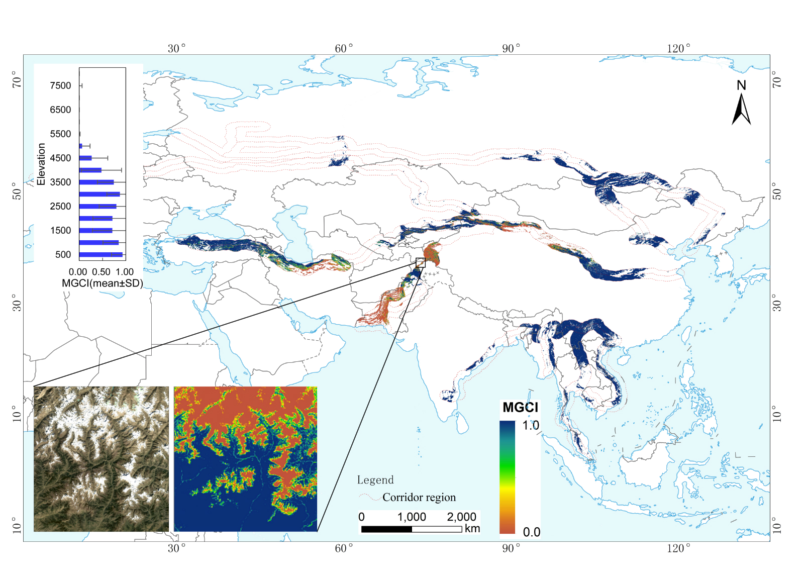
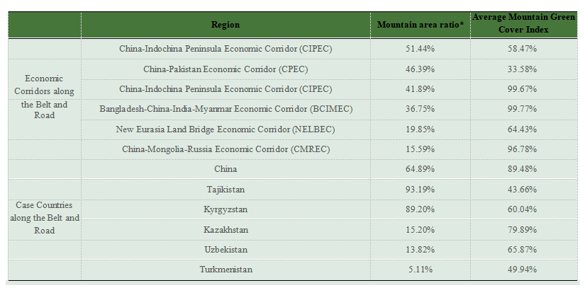
Figure 1 displays the detailed spatial patterns for the gridded Mountain Green Cover Index at the economic corridor and country scale. The statistics for the average mountain area ratio and the index are shown in Table 1. The proportion of mountain areas was ranked highest to lowest as: the China, Central Asia, and West Asia Economic Corridor (CCWAEC, 51.44%), China-Pakistan Economic Corridor (CPEC, 46.39%), China-Indochina Peninsula Economic Corridor (CIPEC, 41.89%), Bangladesh-China-India-Myanmar Economic Corridor (BCIMEC, 36.75%), New Eurasia Land Bridge Economic Corridor (NELBEC, 19.85%), and the China-Mongolia-Russia Economic Corridor (CMREC, 15.59%). The Mountain Green Cover Index for BCIMEC, CIPEC, and CMREC was observed to be higher than 96%. The Mountain Green Cover Index for NELBEC (64.43%) and CCWAEC (58.47%) was lower than the above three corridors, while the index for CPEC (33.58%) was the lowest among the six corridors. These results suggest that it is therefore necessary to focus on the protection of mountain biodiversity in the BCIMEC, CIPEC, and CMREC regions, and on eco-environmental protection and vegetation restoration in the CPEC, NELBEC, and CCWAEC regions.
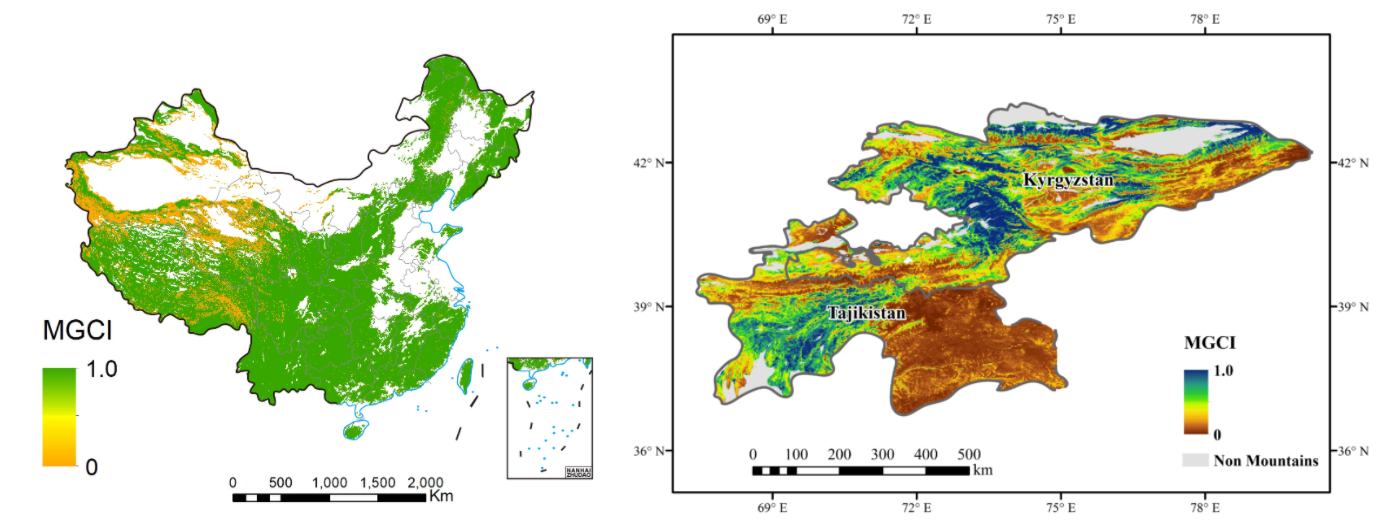
Figure 1. The Mountain Green Cover Index for the Belt and Road Initiative case study area (2015, 1 km). (a) The six economic corridors. (b) China. (c) Kyrgyzstan and Tajikistan. The economic corridor region in (a) was determined by buffering 100 km of the key node cities and traffic lines, while maintaining the integrity of geographic units. The enlarged details in (a) illuminate the Landsat-8 OLI images and Mountain Green Cover Index for the Hindu-Kush Mountains in the CPEC region. The bar plot in (a) reveals the statistics for the Mountain Green Cover Index at different elevations in the economic corridors.
According to the China Digital Mountain Map, mountainous areas in China accounted for 64.89% of the total land area. Moreover, the Mountain Green Cover Index accounted for 89.48% of the total mountain area. The index was observed to follow a heterogeneous distribution pattern. The index values were highest in humid regions, high in semi-arid regions, and lowest in arid regions. The mountain areas in the five Central Asian countries accounted for 15.2% of the total land area in the region. The mountain area ratios for Tajikistan and Kyrgyzstan were 93.19% and 89.2%, with a mountainous green cover index of 43.66% and 60.04%, respectively. Mountains are known as the “lifeline” for the ecology and development of arid regions. The climate of the five Central Asia countries is dry and the mountain ecosystem is fragile. It is therefore necessary to monitor, evaluate, and protect mountain ecosystem health in the region.
Table 1. Statistics for mountain areas and the Mountain Green Cover Index in the Belt and Road Initiative case areas.
*Note: The definition of mountains and calculation of the Mountain Green Cover Index for China is based on the China Digital Mountain map, while the other regions are based on UNEP- World Conservation Monitoring Centre mountain data.
| Highlights |
| The grid-based Mountain Green Cover Index calculation model was developed and reflects the environmental gradient and high spatiotemporal heterogeneity characteristics of mountain areas. Big Earth Data was used to map the Mountain Green Cover Index for six economic corridors and mountain countries along the Belt and Road in 2015. |
Outlook
Big Earth Data is an innovative methodology that can achieve high temporal resolution (e.g., daily, monthly, yearly) and high spatial resolution (>250 m) monitoring of the Mountain Green Cover Index. In the future, it is recommended to consider the three-dimensional characteristics of mountains and explore new indicator monitoring and service models based on multiscale observation and engineering operations. This is necessary due to the highly heterogeneous and vertical zone spectrum characteristics of mountain ecosystems.
The monitoring technology used in this case can be employed for time series monitoring of the Mountain Green Cover Index at global scales and for developing countries. Future studies should explore the relationship between the Mountain Green Cover Index and global climate change as well as human disturbances to develop improved environmental indicators. These indicators guide the implementation of sustainable development measures for mountain areas at regional and national scales.