
SDG15: Life on Land
Identifying land degradation area and risk control countermeasures in Mongolia and along the China-Mongolia railway(2019)
Scale: National
Study area: Mongolia
Mongolia is currently experiencing severe land degradation challenges, which have a direct impact on the ecosystem of the Mongolian Plateau and in adjacent areas. The environmental changes resulting from the land degradation process has also begun to affect local infrastructure. For example, affected infrastructure includes the multinational transportation artery connecting China, Mongolia, and Russia, and the China- Mongolia railway. This effect increases risks to passengers and goods moving along the region's economic corridor. The development of solutions to the issue require an understanding the dynamics of land degradation in the region.
Target 15.3: By 2030, combat desertification, restore degraded land and soil, including land affected by desertification, drought and floods, and strive to achieve a land degradation-neutral world.
Indicator 15.3.1: Proportion of degraded land to the total land area.
Method
Remote sensing land cover products with 30-meter resolution were used to track desertification in Mongolia during 1990, 2010, and 2015. The three phases of land cover data for 1990, 2010, and 2015 were superimposed to obtain maps of land use change in Mongolia from 1990 to 2010 and 1990 to 2015. The distribution of desertified land cover was then calculated for the time period. Buffers with sizes of 5 km, 10 km, 30 km, 50 km, 100 km, and 200 km were created and combined with the distribution of desertified land cover along the China- Mongolia railway and the land degradation changes in 19902010 and 1990-2015. This data was used to analyze the risk to infrastructure from the desertification process in the region.
Data used in this case
Remote sensing data included Landsat TM and OLI images. The imaging time ranged from June to September in 1990, 2010, and 2015. The auxiliary data included DEMs and slope data for Mongolia, Mongolian administrative district data, average annual temperature data, average annual precipitation data and vector data for buffer zones on both sides of the China-Mongolia railway. The data also included statistics for agricultural land, population, and livestock.
Results and Analysis
Results revealed that the recent trends in land degradation featured a strong zonal character. Degraded land was mainly distributed in northwestern and central Mongolia, and spanned from northeast to southwest and from north to south. By 2015, the area of desertified land cover along the China-Mongolia railway (Mongolian section) accounted for about 47.49% of the total area.
The combined effects of natural and socioeconomic factors have resulted in land degradation along the Mongolian section of the China-Mongolia railway. Large temperature fluctuations and reduced rainfall were observed as the natural factors. The land degradation process was also accelerated by over grazing, population migration, infrastructure construction, mineral exploitation, land reclamation for agriculture, and rapid urbanization. The following suggestions are offered to combat the issue. (1) Future planning should focus on farmland reclamation and controlling the growth rate of agricultural land in northern Mongolia. Future plans should also be developed to (2) control urban construction, and to (3) improve mining technology, and regulate the mining industry to discourage harmful practices. (4) Additionally, plans are also required to regulate livestock populations and to ensure reasonable collocation of livestock species. (5) Lastly, the goal should be to improve the region's ability to respond to climate change and a focus on ecological risk prevention and control. This is necessary to promote sustainable development in the China- Mongolia-Russia economic corridor.
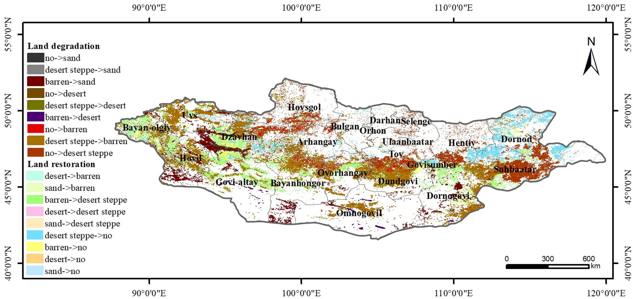
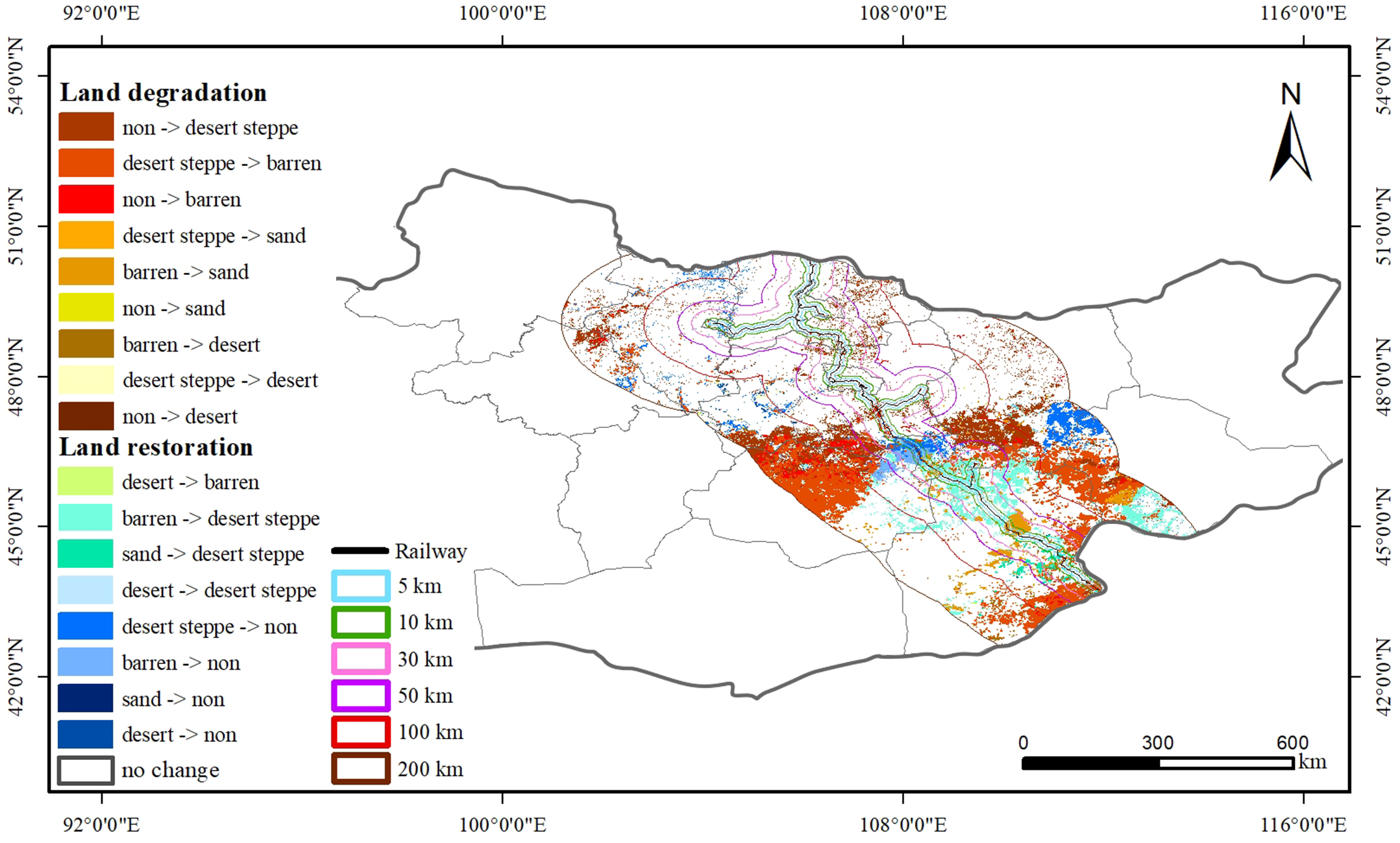
Figure 1. Land degradation distribution for 1990 to 2015. (a) Mongolia, (b) China-Mongolia railway (Mongolian section).
| Highlights |
| Over the past 25 years, the degree of land degradation in Mongolia has gradually increased from northeast to southwest and from north to south. These new land degradation regions have a strong zonal nature and are mainly distributed in northwestern, central, and northeastern Mongolia. Land degradation areas are observed to be expanding northward along the Mongolian section of the China-Mongolia railway. The combined effects of natural and socioeconomic factors have resulted in accelerated land degradation in this region. |
Outlook
Feature space models were constructed using Albedo-NDVI, Albedo-MSAVI (Modified Soil Adjusted Vegetation Index) and Albedo-TGSI (Topsoil Grain Size Index) for three geographical regions. These regions included the central province and its northern region, the Eastern Mongolian plateau, and the southern Gobi region. These datasets were then used to extract desertification information along the Mongolian section of the China-Mongolia railway.
Updated data products for land degradation will be released in the future to provide data support for the prevention and control of land degradation in Mongolia. Future work will be aimed towards developing land degradation risk prevention and control strategies for areas along the main traffic routes of the China- Mongolia-Russia economic corridor and for desertificationsensitive areas in Mongolia.