
SDG15: Life on Land
The proportion of degraded land to the total land area in Central Asia(2019)
Scale: Regional
Study area: Central Asia
Central Asia mostly consists of hot, dry land characterized by a fragile ecological environment. The risk of land degradation in the region is increasing due to the intensification of global climate change and human activities (e.g., water and soil development, mineral resources development, transportation and energy corridor construction, and urban expansion). The prevention and control of land degradation is an important component for guaranteeing ecological security and sustainable socio-economic development in the region.
Target 15.3: By 2030, combat desertification, and restore degraded land and soils, including land affected by desertification, drought, and floods, and strive to achieve a land degradation-neutral world.
Indicator 15.3.1: Proportion of degraded land to the total land area.
Method
Land degradation was assessed by calculating a composite index. A land degradation index (LDI) was calculated using the geometric mean of indicators to monitor land degradation. Land degradation was identified using three measures of change derived from LDI time series data, including: trajectory, performance, and states suggested by the UNCCD.
Data used in this case
The datasets included MODIS data products, a CCI-LC dataset, and soil taxonomy units developed by the United States Department of Agriculture. The indicator datasets included: NDVI, albedo, LST, a Temperature-Vegetation Dryness Index (TVDI), and a Modified Soil-Adjusted Vegetation Index (MSAVI). The NDVI, albedo, and LST were derived from MOD13A1, MCD43A3, and MOD11A2, respectively. MSAVI and TVDI datasets were provided by CASEarth.
Results and Analysis
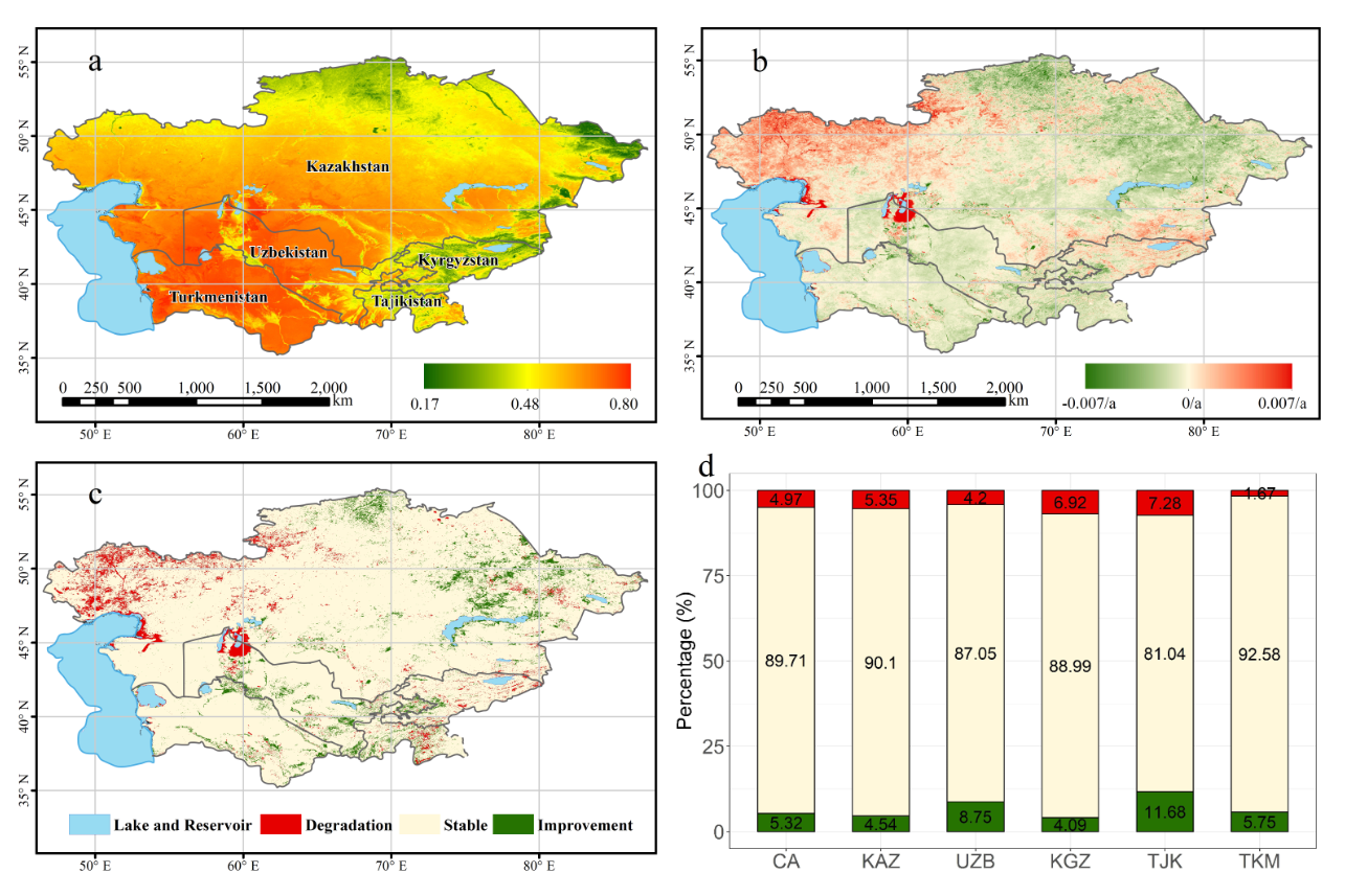
Most of the land degradation was observed in the western part of Central Asia, whereas most of the land improvement occurred in eastern Central Asia. Land degradation around the Aral Sea was more serious than that in other regions. In Central Asia, 4.97% of total land area exhibited land degradation, whereas 5.32% of total land area was categorized as land improvement. The proportions of land degradation in Kazakhstan and Kyrgyzstan was 5.35% and 6.92%, respectively, which was greater than improved land areas. In contrast, the land improvement areas in Uzbekistan, Tajikistan, and Turkmenistan accounted for 8.75%, 11.68%, and 5.75% of the total area, respectively, which were greater than the amount of land degradation areas.
Tajikistan and Kyrgyzstan had the highest proportion of land degradation compared to the other Central Asian countries. The lowest proportion (1.67%) of land degradation was identified in Turkmenistan. Higher percentages of land improvement were found in Turkmenistan and Uzbekistan than in other countries. The lowest proportion (4.09%) of land improvement was observed in Kyrgyzstan.
Figure 1. Spatial distribution and trends in LDI from 2000 to 2018. (a) Spatial distribution of the mean LDI. (b) Annual change in LDI. (c) Land cover change classified into three classes, including: land degradation, stable areas, and land improvement. (d) Percent change in DI for different countries. Note: CA refers to the five Central Asian countries, where KAZ: Kazakhstan, UZB: Uzbekistan, KGZ: Kyrgyzstan, TJK: Tajikistan, and TKM: Turkmenistan. Both (d) and (c) have the same legend.
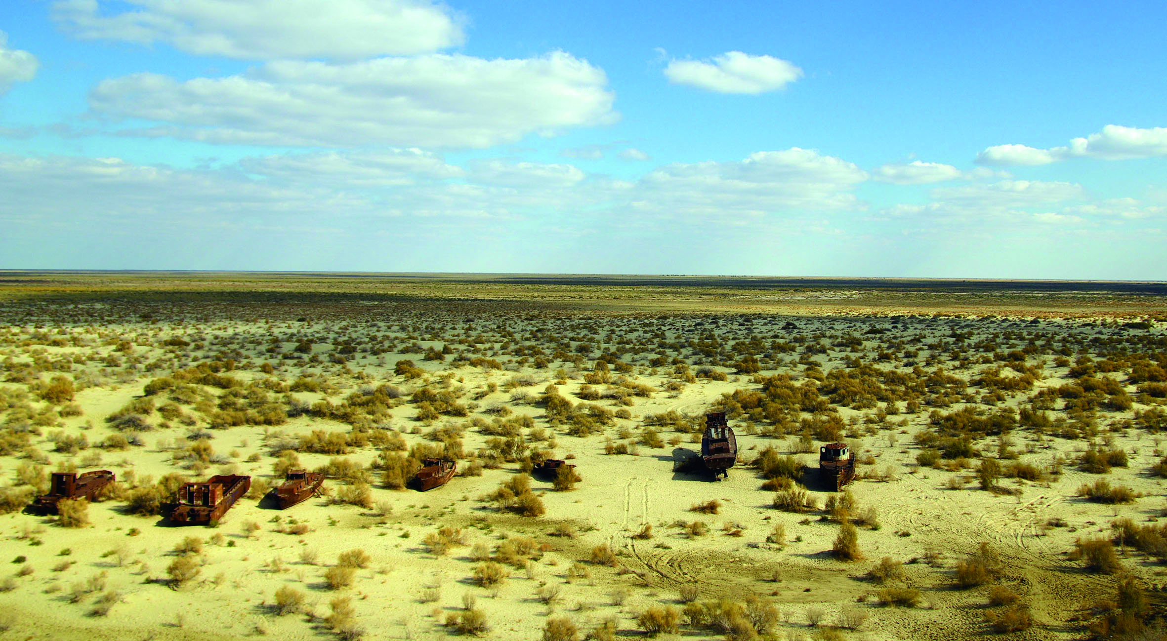
Figure 2. This area was once the Aral Sea.
| Highlights |
| From 2000 to 2018, land degradation in Central Asia mainly occurred in the west, while land improvement was concentrated in the east. The most serious case of land degradation occurred near the Aral Sea. Land degradation in Central Asia accounted for 4.97% of the total area. Both Kazakhstan and Kyrgyzstan had high rates of land degradation with values of 5.35% and 6.92%, respectively. |
Outlook
The land degradation evaluation index system can provide a new data source for the SDG 15.3.1 indicator in inland arid areas.
In the future, the identification of land degradation areas should be the main spatial targets for the deployment of restoration plans. This can provide a decision-making reference for the implementation of the land degradation neutrality initiative for regional governments.
The major drivers of the land degradation process will be investigated in future studies, especially in the area surrounding the Aral Sea.