
SDG15: Life on Land
Evaluating the effectiveness of the management of protected areas: an example from Qianjiangyuan National Park in China(2019)
Scale: Local 

Study area: Qianjiangyuan National Park, China
Protected areas, including national parks, nature reserves, wilderness areas, and community-conserved areas, represent a primary means for preventing global biodiversity loss. Assessing the effectiveness of protected areas on biodiversity conservation usually involves two dimensions. First, the coverage of Key Biodiversity Areas (KBAs) by protected areas is assessed at global, regional, or national scales to ensure that important biodiversity areas are included in the protected area system. Secondly, the rationality of the spatial planning and management effectiveness are evaluated at the scale of a single protected area. This is required to ensure that the protected area can effectively protect biodiversity after it is established. Significant progress has been made toward expanding the spatial extent of protected areas. For example, 15% of terrestrial and freshwater environments are now covered by protected areas. However, the effectiveness of existing protected areas is constrained by extensive human activities within their boundaries as well as protected area downgrading, downsizing and degazettement (PADDD). Numerous studies have examined the effectiveness of protected areas using different indicators, yet there is a lack of systematic monitoring data and indicators for assessing the effectiveness of management practices.
Qianjiangyuan National Park was one of the first ten pilot national parks in China. The park was established to protect a large area of low lying zonal evergreen broadleaved forests in Eastern China (Figure 1). It is home to two of China's endemic species, the first-class protected black muntjac (Muntiacus crinifrons) and Elliot's pheasant (Syrmaticus ellioti). The park also provides important ecosystem services relating to water provisions for the developed region in the Yangtze River Delta, Eastern China. Qianjiangyuan National Park was used as an example in this case study, and an indicator system was developed to evaluate the effectiveness of protected area management. A corresponding biodiversity monitoring platform was also established to provide data support for the calculation of indicators. This enables a comparison of management effectiveness between protected areas, and the integration of data from different areas for evaluation at regional and global scales.
Target 15.1: By 2020, ensure the conservation, restoration, and sustainable use of terrestrial and inland freshwater ecosystems and their services. This includes forests, wetlands, mountains, and drylands, and is in line with obligations under international agreements.
Indicator 15.1.2: Proportion of important sites and ecosystems for terrestrial and freshwater biodiversity that are covered by protected areas.
Figure 1. A lowland evergreen broad-leaved forest in Qianjiangyuan National Park (left). A first-class protected animal known as the black muntjac (above right). Elliot's pheasant (bottom right).
Figure 2. (a) National park plant and animal diversity monitoring platforms. Each infrared trigger camera was set up in a forest dynamics plot.
(b) Digital surface model (DSM) of the national park remote sensing platform.
Method
The management effectiveness of protected areas was assessed using the following three indicators: (1) the area and degree of fragmentation of key target ecosystems, (2) the change in population size for key protected plants and animals, and (3) ecosystem functions as indicated by above-ground biomass and carbon stock.
Three biodiversity monitoring platforms were established based on the above indicators to obtain data for Qianjiangyuan National Park (Figure 2).
(1)The national park plant diversity monitoring platform involved dividing the entire park into a 1x1 km grid and the construction of 641 plots with an area > 0.04 ha (Figure 2a). All freestanding stems that were > 1 cm in diameter at breast height were censused in each plot. Eight 2x2 m subplots and 1x1 m subplots were established for monitoring shrubs and herbs, respectively.
(2)In the national park animal diversity monitoring platform, an infrared trigger camera was installed in 1x1 km grid cells to monitor animal diversity and population dynamics (Figure 2a).
(3)In the national park remote sensing platform, forest canopy structures were obtained for the entire park using light detection and ranging (LiDAR). Moreover, the functional traits of plant leaves were retrieved using hyperspectral remote sensing data (Figure 2a).
The data from the three biodiversity monitoring platforms was integrated to evaluate the management effectiveness of Qianjiangyuan National Park. Forest communities were classified using the data from the forest dynamics plots and remote sensing imagery. The area and fragmentation indices for subtropical evergreen broad-leaved forests were calculated for the entire national park. The abundance and inter-annual change in population size of the black muntjac and Elliot's pheasant were estimated in the national park using the N-mixture model based on the data from infrared trigger cameras. The aboveground biomass and carbon stock of the forest ecosystem was estimated at the forest plot level using data from forest dynamics plots. These results were scaled up to the level of the entire national park and combined with remote sensing imagery.
Data used in this case
The field survey data included 641 forest dynamics plots with an area of > 0.04 ha and an infrared trigger camera monitoring network constructed on a 1x1 km grid. The remote sensing datasets included LiDAR and hyperspectral data, and a digital orthophoto map.
Results and Analysis
(1)Results revealed that evergreen broad-leaved forests covered 5,827.1 ha, or 23.1% of the total area in Qianjiangyuan National Park. About 89% of the forests were located in core conservation and restoration areas. The largest patch of evergreen broadleaved forest accounted for 16.4% of the core conservation area. Plantation forests accounted for 26% of the total area in the park. There are still large areas consisting of old-growth evergreen broad-leaved forests in the neighboring areas.
(2)The mean amount of above-ground carbon stock was estimated to be 86.2 mg/ha, and ranged between 75 and 100 mg/ ha. The largest carbon stock (228.5 mg/ha) was found in old- growth evergreen broad-leaved forests. Conversely, the lowest carbon stock (18.1 mg/ha) was found in secondary forests 30 years after clear-cut tree harvesting, which accounted for one- twelfth of the carbon stock of old-growth forests.
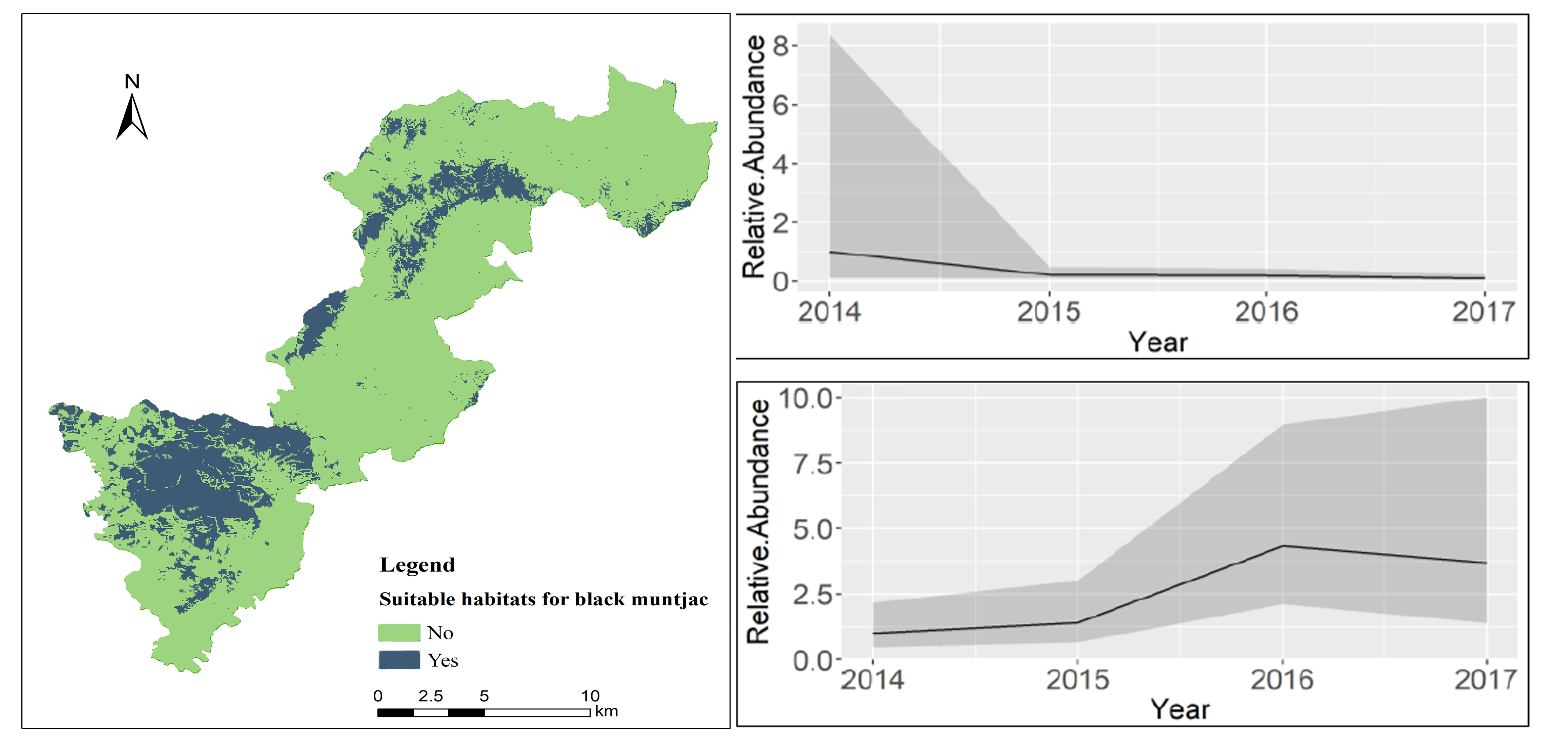
(3)The total area of suitable habitats for the black muntjac was 4,250 ha and accounted for 16.9% of the park. Moreover, 69.3% and 30.4% of suitable habitats were located in the core conservation and ecological conservation areas, respectively. This result indicates that the existing functional zoning of the national park can effectively protect black muntjac habitats (Figure 3a).
(4)The population of black muntjac significantly declined during 2014-2017, and the population of Elliot's pheasant increased during this period (Fig. 3b, c).
(5)Results demonstrate that the functional zoning of Qianjiangyuan National Park is effective for protecting evergreen broad-leaved forests and endangered animal habitats. However, the population size for the black muntjac was observed to significantly decrease, and requires further monitoring and conservation. Cross-border cooperation is necessary to protect evergreen broadleaved forests and endangered animal habitats, and for restoration of plantation forests to improve the effectiveness of national park management.
Figure 3. Distribution of suitable habitat patches for black muntjac in Qianjiangyuan National Park (a). The variation in relative abundance for black muntjac (b) and Elliot's pheasant (c) during 2014-2017.
| Highlights |
| Three biodiversity monitoring platforms were developed to collect data to assess the effectiveness of management in Qianjiangyuan National Park. The park conserves a large area of low-lying zonal evergreen broadleaved forest as well as a large area of suitable habitats for the black muntjac, an endangered species. These indicators assess ecosystem integrity in Qianjiangyuan National Park. In 2014-2017, the population size of Elliot's pheasant was observed to increase, but the population of the black muntjac had significantly declined. Additional monitoring and conservation efforts are necessary to understand the cause of this phenomenon. Furthermore, cross-border cooperation is required to protect evergreen broadleaved forests and endangered animal habitats. Such efforts are also necessary for restoring plantation forests in the park and to improve the effectiveness of park management. |
Outlook
The biodiversity monitoring indicator system established in this study promotes the assessment of management effectiveness in protected areas. Currently, the specific indicator system has only been applied to Qianjiangyuan National Park. Appropriate indicators should be selected based on the type and characteristics of ecosystems. The characteristics of the protected area should be considered when applying the monitoring scheme to other protected areas.
The accuracy and timeliness of the management assessment of protected areas can be improved using various methods. For instance, it is recommended to perform in-depth research on the correlation between ground observation data (e.g., vegetation dynamics plots and infrared camera datasets) and near-surface remote sensing. There is also a need to develop new indices for retrieving biodiversity patterns based on near-surface remote sensing, and to enhance the application of “Space-Air-Ground” integrated biodiversity monitoring platforms.