SDG15: Life on Land
Forest cover mapping to monitor terrestrial ecosystems in Southeast Asia(2019)
Scale: Regional

Study area: Southeast Asia
Forests not only provide significant products and services for human survival and development but also are critical in mitigating climate change due to their carbon sequestration effect. Therefore, forest management, restoration, and conservation are extremely important to human civilization. The creation of a forest resource inventory is an essential step in sustainable forest management. It is necessary to track the changes in forest resources to develop effective policy and management guidelines for public and private investments in these areas. Such policies are required to protect forest resources and promote social and economic development and ensure ecosystem stability. This enables forest resources and services to be preserved for future generations. Currently, there are limitations in the temporal and spatial resolutions for forest cover mapping, which makes it difficult to accurately map land cover changes in forests. High temporal and spatial resolution data with high accuracy can be used to overcome these problems and provide data support for the sustainable development of forest resources.
Target 15.1: By 2020, protect, restore, and promote the sustainable use of land and inland freshwater ecosystems, especially forests, wetlands, foothills and dry lands.
Indicator 15.1.1: The proportion of forest area to the total land area.
Method
This case study presents a process for monitoring woodlands in Mainland Southeast Asia using the Google Earth Engine (GEE) cloud computing platform. A set of automated algorithms was designed to compare the remote sensing images from the MODIS and Landsat systems. This is necessary since remote sensing images of tropical regions tend to have high percentages of cloud cover. The high temporal resolution of MODIS data aids in screening Landsat images with poor cloud removal effects, and helps to avoid manual examination of images. This was followed by multi-temporal data fusion on the GEE platform, which can reduce the interference of sensors, imaging conditions, and other factors, and generates stable and quarterly continuous NDVI sequences. Furthermore, vegetation can be extracted using established rules. Finally, a classification sample library was developed using ground survey samples and visual interpretation results of high-resolution Google Earth images. Forests were extracted after classifying vegetation areas using the fusion of Landsat and Sentinel-2 multi-band data. The extraction results were verified using high-resolution Google Earth imagery and field sample data. The results reveal that the method (1) can effectively reduce errors and improve the accuracy of forest extraction using single-temporal data, and (2) the method also achieves rapid high-resolution extraction of forests.
Data used in this case
Landsat series remote sensing images, MODIS images (NBAR products), and Sentinel-2 optical images for forest cover mapping.
High-resolution Google Earth imagery and field sample data for data validation.
Results and Analysis
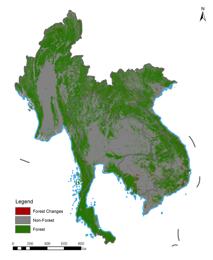
Figure 1 shows the distribution of forests in Mainland Southeast Asia and woodlands which was altered over the course of three years due to deforestation, forest fires, and the growth of new woodlands. There was a relatively high proportion of forested areas in the five countries located in Mainland Southeast Asia. Laos was observed to have the greatest proportion of forested land, while Cambodia had the lowest. Cambodia is located at a relatively high altitude and has large areas consisting of sparse forests, sparse trees, and weeds that were excluded from our analysis. The changes in woodland land cover was compared with high- resolution historical images from Google Earth. Results revealed that the changes in woodland area were mainly caused by human activities, including deforestation and the construction of new plantations in Vietnam and Thailand, and mining and quarrying in Laos and Cambodia.

Fiure 1. Forest cover of the Indochina Peninsula in 2018.
| Highlights |
| Forest cover dataset of Mainland Southeast Asia from 1990 to 2018 was obtained. An abundant amount of forest resources was discovered in the Mainland Southeast Asia. Laos featured the largest forested area, while the smallest area was observed in Cambodia. Human activities such as deforestation, mining, and quarrying of forested areas were the major factors causing changes in the distribution of forest land in the region. |
Outlook
The forest extraction algorithm will be extended to other countries in Southeast Asia, and the high-resolution and high- precision forest remote sensing products in Southeast Asia will be released and updated every three to five years.
Changes in forested areas will be monitored in real time using remote sensing products. A quota will be developed to monitor and measure forest resources according to SDG 15.1.1, or the “proportion of forested area to land area”.

