
Monitoring changes in raft culture in China's coastal waters(2020)
Target 14.2: By 2020, sustainably manage and protect marine and coastal ecosystems to avoid significant adverse impacts, including by strengthening their resilience and take action for their restoration, to achieve healthy and productive oceans.
| Highlights |
| Dynamic monitoring datasets (at 30 m spatial resolution ) of the distribution of raft culture in key coastal provinces of China in 2017, 2019 and 2020 are generated for the first time, aided by deep learning. Findings indicate that the area of marine raft culture in China is still in the growth phase, while the area of raft culture within the boundaries of the coastal ecological conservation red line has remained stable on the whole. |
Background
Marine raft culture is an important form of marine aquaculture. It has three subsets, namely, floating raft culture, cage culture and longline culture. Compared to nearshore pond and mudflat aquaculture, raft culture is more difficult to manage because it is further away from the coast. Because raft culture tends to be scattered around a large area, traditional monitoring methods, such as onsite measurement using navigation and positioning systems, is labor-intensive, time-consuming and unproductive when accurate results of a large area are required. As an important part of Big Earth Data, satellite imagery can help overcome the inadequacies of field survey and is a reliable, state-of-the-art technology for safe and effective multi-temporal dynamic monitoring of marine raft culture across large areas.
Data used
◎ Gaofen-3 and Sentinel-1/2 satellite imagery of China's coastal waters for 2017, 2019 and 2020, of which the 2017 and 2019 data were for the period April to September of each year and the 2020 data, from April to June.
◎ Validated field survey data of marine raft culture for 2018.
◎ Policy data, including data on red line planning for the protection of marine ecosystems.
Method
For the purposes of this study, an AI-enabled remote sensing approach that supports large-area, complex-scenario monitoring of marine raft culture farms was used. A large number of representative samples were selected along the south-north axis, to ensure the applicability of models obtained through machine learning to different scenarios. In view of the unique characteristics of remotely sensed imagery of raft culture farms, multi-core convolutional layers, additional texture features and other enhancements were used to improve the deep learning neural network.
Results and analysis
In this study, Jiangsu province and Fujian province were chosen to be monitored for changes in their raft culture farms (Fig. 6-6 and Fig. 6-7). It is found that most of raft culture farms are located close to shore. From 2017 to 2020, the total area of raft culture in the two provinces was in the growth phase, with a slowdown in the rate of growth.
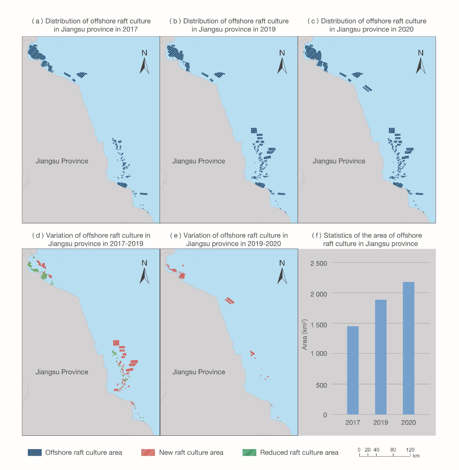
Figure 6-6. Observed distribution, and change thereto, of raft culture in Jiangsu province
Furthermore, a change analysis in the context of the ecological protection red line finds little change to most of the marine aquaculture within the boundaries of the red line after the red line came into force.
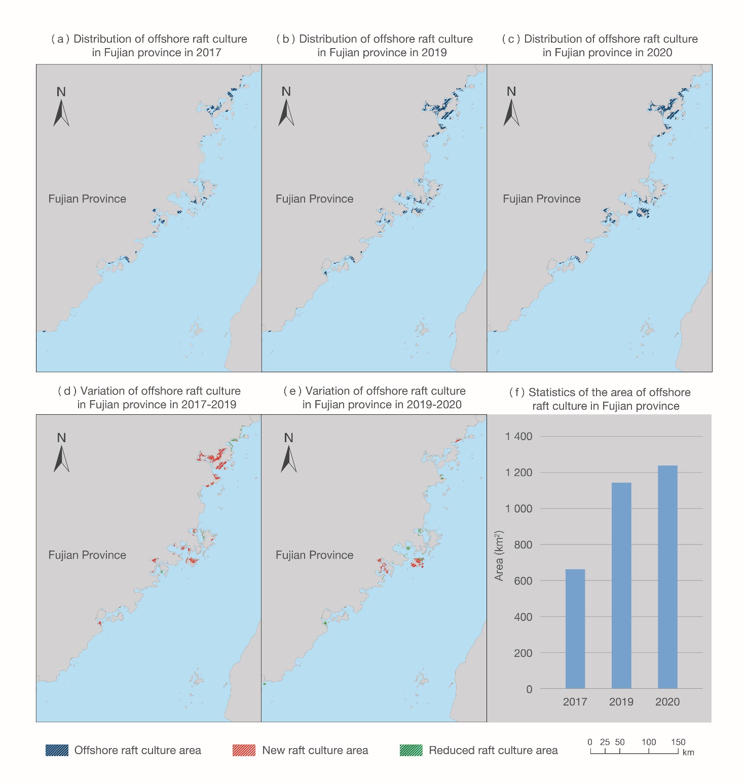
Figure 6-7. Observed distribution, and change thereto, of raft culture in Fujian province
Outlook
Marine aquaculture is not only an important means whereby marine resources are used for human purposes, but also an important factor that has a bearing on the health of marine ecosystems. While large-scale, whole-area monitoring using traditional methodology for aquaculture survey is very challenging, the increasing availability of satellite remote sensing data and other Big Earth Data provides a new way of overcoming this problem. Going forward, we shall extend the application of Big Earth Data to the relevant domains, determine the optimal remote sensing time slots for different raft culture farms in various marine areas, and improve the accuracy and timeliness of information obtained from marine aquaculture monitoring in terms of type, scale, period and any change in the aquaculture farm environment.