
SDG6: Clean Water and Sanitation
Dynamic change of water body in Ramsar Sites(2020)
Target: 6.6 By 2020, protect and restore water-related ecosystems, including mountains, forests, wetlands, rivers, aquifers and lakes.
| Highlights |
| Based on the long-term water body dataset with high time resolution, the dynamic changes in water areas in Ramsar Sites were analyzed. The results showed that from 2000 to 2018, 50% of the Ramsar Sites in Asia, Europe, and Africa exhibited a trend of significant change, and most of them (58%) an upward trend. |
Background
The dynamic monitoring of the water bodies in the Ramsar Sites can directly or indirectly reflect the trend of changes and protection effect of the wetland ecosystem (Zheng et al., 2012). At present, there are 171 Contracting Parties to the Ramsar Convention on Wetlands committed to wetland conservation and management. By May 2020, there were 2 391 wetland reserves on the Ramsar Sites List, covering a land area of 2.53×10⁶ km2.
The United Nations Water (UN-Water) has provided datasets related to SDG 6.6.1, including surface water, mangroves, reservoirs, and wetlands, based on the Global Surface Water Explorer (Pekel et al., 2016) and Global Lakes and Wetlands Database (Lehner and Doll, 2004) developed by the Joint Research Centre of the European Commission (JRC). However, there is no direct and comprehensive monitoring and evaluation of the ecological status of Ramsar Sites. The dynamic change of the water bodies in Ramsar Sites has a direct impact on the ecological environment of such reserves.
Data used
Boundaries of Ramsar Sites in Asia, Africa and Europe (2020).
Global water bodies dynamic datasets from 2000 to 2018, Aerospace Information Research Institute, Chinese Academy of Sciences, with a spatial resolution of 250 meters and temporal resolution of 8 days (Han and Niu, 2020).
Watershed boundaries data (2000), World Wide Fund for Nature (WWF) .
Method
This case study selected 86 representative inland Ramsar sites and their corresponding 51 basins in Asia, Europe, and Africa. The overall trend of changes in the water bodies and the inter-annual trend of variation within a year was analyzed using the least square linear regression method, and the significance level of the changes was tested through double tail t-test (0.05). According to the time series water body datasets, the water bodies were further divided into three types: permanent water bodies, seasonal water bodies, and temporary water bodies; their change trends were extracted through wavelet transform and time series decomposition method. Seven typical Ramsar sites of varying degrees of change were further selected for analysis and assessment of water body changes.
Results and analysis
In general, 50% (43/86) of the selected Ramsar Sites showed significant water body changes (Fig. 1). Among them, 25 sites showed increase and 18 decrease. In terms of stability (intra-annual variation) of water bodies in Ramsar Sites, the vast majority (83%) sites remained relatively stable. The water fluctuation level rose in less than 6% (5/68) of the Ramsar Sites, while the level dropped in 12% (10/86).
Different water body types (permanent, seasonal and temporary) of Ramsar Sites showed different change patterns. In the Boeng Chhmar and Lake Burdur reserves, despite increase in temporary water bodies, the total area of water bodies showed a downward trend due to the decrease in permanent water bodies.
Because of the increases in permanent water bodies (2/5) and temporary water bodies (3/5), there was an upward trend in the five Ramsar Sites—Rawa Aopa Watumohai National Park, Central Marshes, Vallée de la Haute-sure, Keta Lagoon Complex Ramsar site, and Lake Baringo.
The changes in water bodies in the basins where the Ramsar Sites are located demonstrated different features from those within the Ramsar Sites. For six Ramsar Sites, the water bodies in the basins where they are located exhibited a downward trend, mainly due to the decreases in permanent water bodies in the basins and also related to the changes in seasonal water bodies (basins of Rawa Aopa Watumohai National Park and Keta Lagoon Complex Ramsar) and temporary water bodies (basins of Boeng Chhmar and Lake Baringo). However, the water bodies of the basin of Keta Lagoon Complex Ramsar Site showed a significant upward trend.
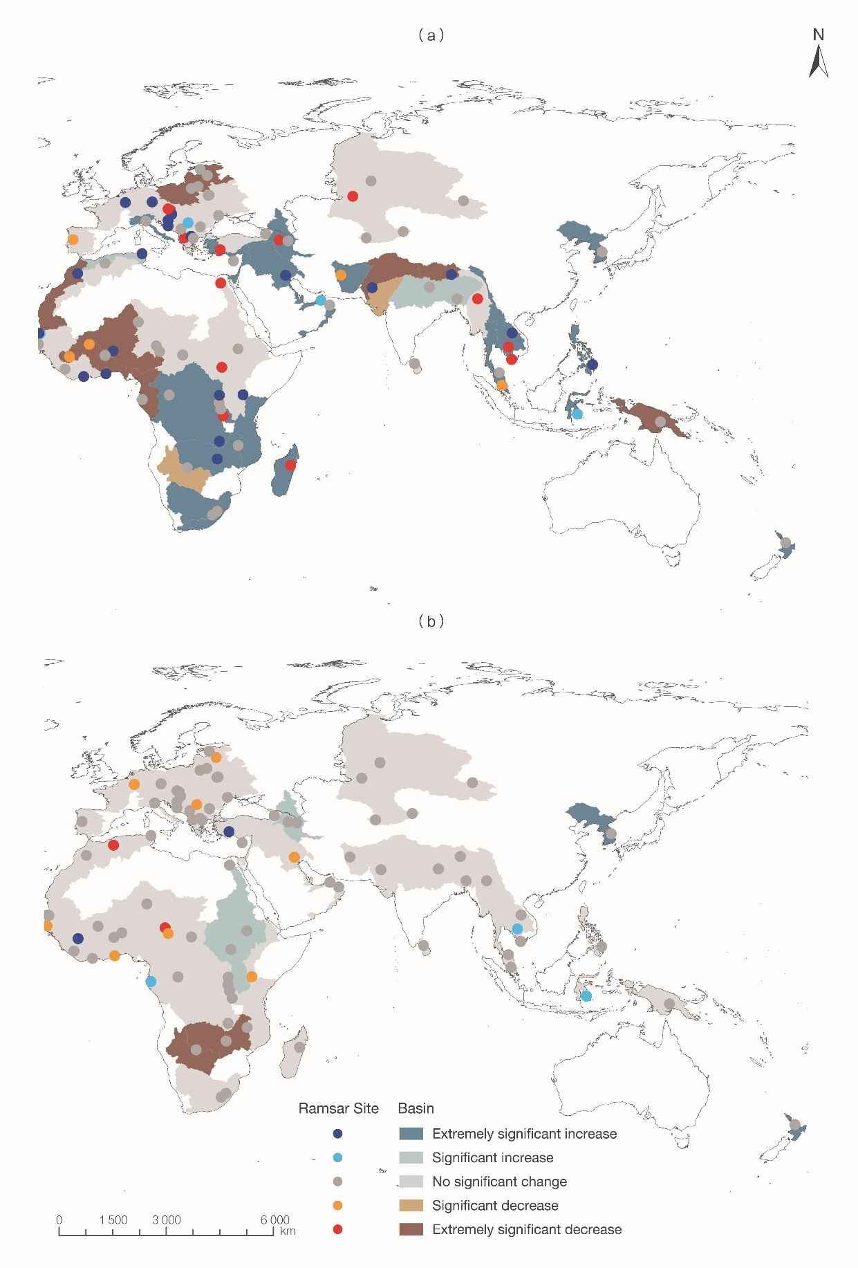
Figure 1. The variation trend of the water area of Ramsar Sites and their basins from 2000 to 2018
(a) Interannual variation trend; (b) Seasonal fluctuation characteristics
Outlook
The case study assessed some Ramsar Sites selected from a multitude of them for the significant changes in their water bodies. In the future, such monitoring can be extended to all Ramsar Sites on a global scale. To achieve SDG 6.6.1, it is necessary to speed up the development of global remote sensing mapping products of water-related natural ecosystems (Hu et al., 2017; Zheng et al., 2015), and research on theories and methods for the monitoring and evaluation of Ramsar Sites and related protected areas.