
SDG6: Clean Water and Sanitation
Spatiotemporal distribution of China's vegetated wetlands(2020)
Target: 6.6 By 2020, protect and restore water-related ecosystems, including mountains, forests, wetlands, rivers, aquifers and lakes.
| Highlights |
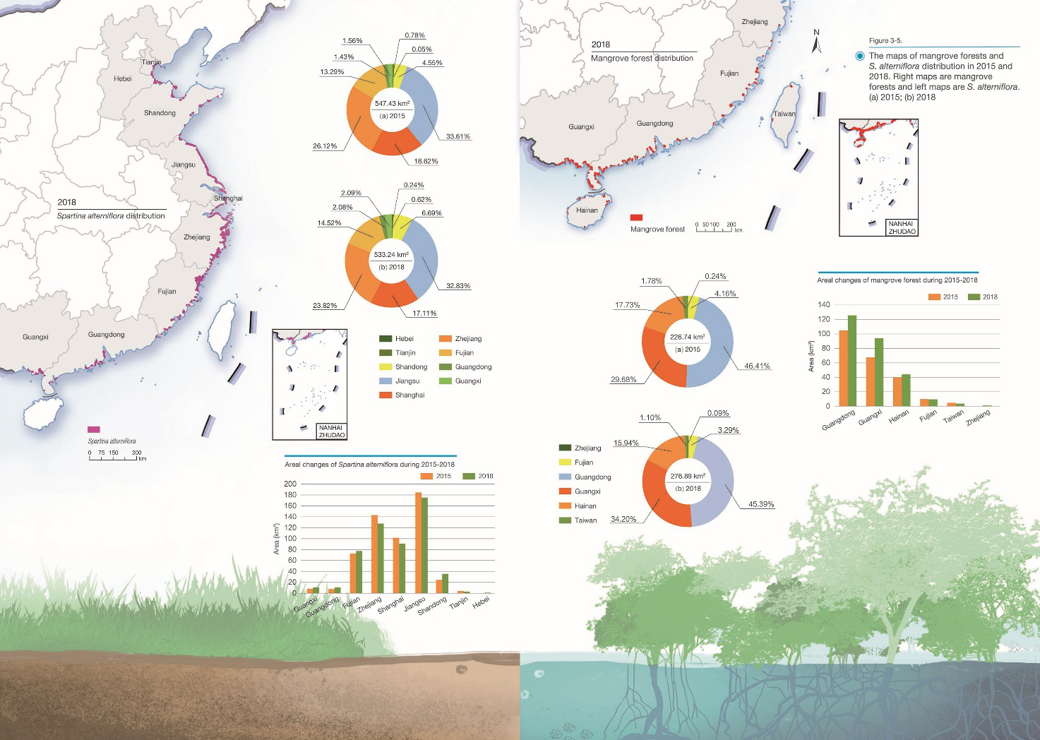
| Analysis of the spatial distribution of China's vegetated wetlands in 2015 and measurement of changes in mangrove forests and Spartina alterniflora in China between 2015 and 2018 showed that the net increase in mangrove forests was 22.11%, and the net decrease in invasive Spartina alterniflora was 2.59%. In China, mangrove forests have been significantly restored and the invasion of Spartina alterniflora was under effective control. |
Background
Wetland is a key component of the life community comprising mountains, rivers, forests, fields, lakes, and grasses. Their protection and management is critical to the Building a Beautiful China Campaign. Analysis of changes in wetlands' spatiotemporal distribution is an important basis for assessing the national achievement of SDG 6.6, and will also provide key data to support the implementation of the Ramsar Convention on Wetlands.
Data used
Landsat-8 Operational Land Imager (OLI) images (2015 and 2018).
DEM, vector data of administrative division, 1:1 000 000 vegetation type map, climatic zones map, global water distribution maps (2015 and 2018).
Massive ground survey samples, governmental statistical and monitoring data.
Method
This case study applied the Hybrid Object-based and Hierarchical Classification (HOHC) approach to map national vegetated wetlands. The work flow includes: first, select remote sensing data of different seasons as data sources by climatic zone and vegetated wetland type; second, classify wetland based on multi-scale segmentation and the hierarchical decision tree method; third, validate or correct classification results based on massive field survey samples (Jia et al., 2018; Mao et al., 2019, 2020). Finally, datasets of China's vegetated wetlands in 2015 and mangrove forests and Spartina alterniflora (S. alterniflora) in 2015 and 2018 were obtained, with an overall accuracy of classification for the former at 95% and for the latter over 92%.
Results and analysis
1) Spatial patterns of China's vegetated wetlands
Vegetated wetlands in China were estimated to be 1.64×10⁵ km2 in 2015, including inland vegetated wetlands (98%) and coastal vegetated wetlands (2%) (Fig. 1). China's vegetated wetlands were observed mainly in Tibet, Qinghai, Inner Mongolia, Heilongjiang, and Xinjiang. They were primarily distributed in areas with annual precipitation between 300 and 600 mm and elevation below 200 or above 3 000 m.
2) Spatiotemporal distribution and areal changes of mangrove forests in China
Mangrove forest is an important part of global biodiversity that must be protected. In recent years, China has been continuously strengthening the protection and restoration of mangrove forests, and has become one of the few countries in the world with net increase in mangrove forest area. In 2018, the Guangdong-Hong Kong-Macao Greater Bay Area had the largest mangrove area, followed by Guangxi and Hainan. The three regions have 95% of the country's total mangrove forest areas. From 2015 to 2018, mangrove areas in China increased from 226.74 km2 to 276.89 km2 with a net increase of 22.11 % (Fig. 2). The areal extent of mangrove forest increased significantly in Guangxi and Guangdong, increased slightly in Hainan, and decreased slightly in Taiwan province.
3) Spatial distribution and areal changes of S. alterniflora in China
The invasive S. alterniflora has been regarded as one of the main threats to ecological security along Chinese coasts. In 2018, S. alterniflora was primarily observed in four provinces/municipality: Jiangsu, Zhejiang, Shanghai, and Fujian. The largest areas invaded by S. alterniflora were in Jiangsu, accounting for one third of the total invaded areas in the country. Such areas decreased from 547.43 km2 in 2015 to 533.24 km2 in 2018, with a net decline of 14.19 km2 (Fig. 2). Due to human control and aquacultural expansion, among others, four provinces/municipalities—Zhejiang, Shanghai, Jiangsu, and Tianjin—saw areal declines of S. alterniflora, particularly in Zhejiang with the largest area decline of 15.52 km2. Despite overall areal decline across the country, certain regions still faced a severe invasive trend, for example the Yellow River Delta. No S. alterniflora was observed in Taiwan and Hainan provinces.

Figure 1. The map of vegetated wetlands distribution in 2015
Outlook
This case study developed an HOHC method to map vegetated wetlands in China and applied it to establish datasets of China's vegetated wetlands in 2015 and mangrove forests and S. alterniflora in 2015 and 2018 with high mapping accuracy. These datasets can provide an important scientific basis for evaluating SDG 6.6 at the national scale.
This case study finds that: (1) Since 2015, the area of mangrove forests in China has increased markedly, which means a great contribution to the global protection and restoration of mangrove forests; (2) From 2015 to 2018, the area in China invaded by S. alterniflora showed a trend of net decrease, reversing the previous upward trend, suggesting that the actions of S. alterniflora control in China had produced initial results.