
SDG6: Clean Water and Sanitation
Surface water changes in Central Asia(2019)
Scale: Regional
Study area: Central Asia
In recent decades, the spatial and temporal distribution of surface water has undergone significant changes due to the influence of both climate change and human activity. The change in surface water distribution has resulted in serious social (e.g., water conflict) and ecological (e.g., ecosystem degradation) issues in many regions. Monitoring and analyzing surface water systems, their changes in surface area, and the protection and restoration of these aquatic ecosystems are included in the 2030 Agenda for Sustainable Development.
A 16-meter spatial resolution surface water dataset for Central Asia in 2018 was developed by using Chinese GF-1 satellite images as data sources, referenced to the Global Surface Water dataset from 2000 to 2015. This dataset provides support for the analysis of water-related ecosystem changes in the region.
Target 6.6: By 2020, protect and restore water-related ecosystems, including mountains, forests, wetlands, rivers, aquifers, and lakes.
Indicator 6.6.1: Change in the extent of water-related ecosystems over time.
Method
The threshold segmentation method employs a single band with one-by-one segmentation of water bodies. This method was used to extract the surface water boundaries in the case study. The remote sensing images acquired by the GF-1 satellite with a wide field of view (WFV) camera were used as the data source (Figure 1). The frequency of surface water occurrence in Central Asia was generated with the JRC and GF-1 derived surface water dataset from 2000 to 2018. The changes in surface water area were analyzed in each country during the 2000, 2005, 2010, 2015, and 2018 periods.

Figure 1. GF-1 satellite WFV images of Central Asia in 2018.
Data used in the case
The study used GF-1 and Landsat 8 satellite remote sensing images from 2016 to 2018. The case study also used the JRC global surface water dataset from 2000 to 2015.
Results and analysis
Surface water in Central Asia was observed to be mainly distributed in the central basin region. Most surface water in this area consisted of seasonal water bodies. The total area for permanent water bodies was observed to be 569,000 km2. The total area for permanent water bodies in Kazakhstan, Kyrgyzstan, Uzbekistan, Turkmenistan, and Tajikistan was 368,000 km2, 6,974 km2, 6,607 km2, 5,189 km2, and 1,330 km2, respectively (Figure 2).
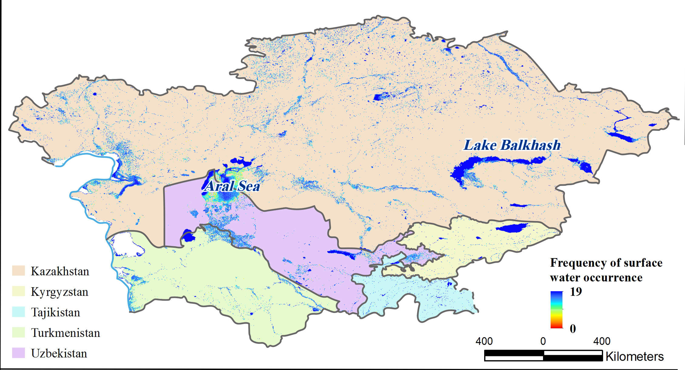
Figure 2. Frequency of surface water occurrence in Central Asia from 2000 to 2018.
There was a decrease in surface water area in Central Asia from 2000 to 2018. In this period, the total area of surface water decreased by 19.9%, from 134,919 km2 to 108,004 km2. The surface water area in Kazakhstan, Kyrgyzstan, and Tajikistan increased from 2000 to 2005, decreased from 2005 to 2015, and then increased again from 2015 to 2018. The surface water area in Turkmenistan increased from 2000 to 2005, and decreased thereafter. The surface water area in Uzbekistan was also observed to continually decrease (Figure 3). The changes in surface area in Kazakhstan and Uzbekistan were mainly caused by the shrinkage of the Aral Sea.
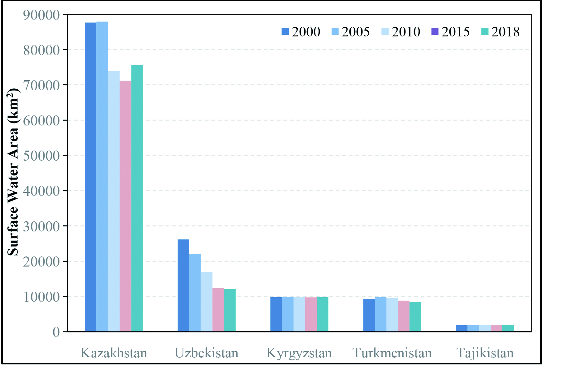
Figure 3. Change in surface water area for each country in Central Asia from 2000 to 2018.
| Highlights |
| The surface water in Central Asia was found to be mainly distributed in the central basin region. However, this area was found to consist mostly of seasonal water bodies. Moreover, the surface water area in Central Asia was revealed to decrease from 2000 to 2018. China's high spatial resolution satellite remote sensing images can provide ideal data sources for monitoring the dynamic changes in surface water in Central Asia. |
Outlook
Turface water annual change dataset from 2016 to 2019 will be completed by 2020 using Landsat 8 and Sentinel-2 and combined with JRC global surface water datasets from 2000-2015. The dynamic changes of surface water in each country will be analyzed once every five years. The SDG 6.6.1 global analysis report will be written and published.
Along the Belt and Road, several countries and regions with significant variation in surface water will be selected for correlation analysis of dynamic changes in surface water. This also includes an assessment of regional economic and social development and climate change. This will involve collaboration with national management and research institutes in the country to jointly research and explore strategies for protecting and restoring important surface water ecosystems.