
SDG13: Climate Action
Global atmospheric CO2 concentration changes in response to climate change(2019)
Scale: Global
Study area: Global
Controlling and reducing anthropogenic emissions of CO2 is an important way for humankind to mitigate climate change. Surface measurements indicate that annual increase in global CO2 concentration is fluctuating, even though the interannual variability of anthropogenic CO2 emissions is stable (especially during 2010-2016). These fluctuations in CO2 increase could be related to abnormal CO2 absorption and emission of terrestrial ecosystems resulting from extreme climate change. Extreme weather events increase with global warming, caused by the increase in atmospheric CO2 concentration and its radiative forcing, and promote atmospheric CO2 increases with feedback to terrestrial ecosystems. Fully recognizing the increase and decrease in atmospheric CO2 concentration caused by this natural change has important reference value for us to formulate environmental protection, improvement, and restoration policies for controlling the increase in atmospheric CO2 concentration.
Target 13.3: Improve education, awareness, and human and institutional capacity for climate change mitigation, adaptation, impact reduction, and early warning.
Method
Spatiotemporal geostatistical modeling methods were used to estimate global continuous spatiotemporal atmospheric CO2 concentration at a spatial resolution of 1×1 degree and threeday temporal resolution, using the Greenhouse Gases Observing Satellite (GOSAT) for the period from June 2009 to May 2016. Harmonic function composition was used to obtain abnormal residuals, normalization was performed with Z-score, and flood filling algorithms were utilized to extract periods and regions of XCO2 (column-averaged CO2 dry air mole fraction) anomalies. GM-XCO2 (global land maps of XCO2) and CT-XCO2 (XCO2 calculated from the CarbonTracker atmospheric distribution of CO2) were applied together with anomaly change detection methods for comparing results.
A spatiotemporal anomaly change detection method was developed based on time series data fitting to detect regions and periods of abnormal increases in atmospheric CO2 concentrations from 2009 to 2016. The study also adopted global surface skin temperature and inversion parameters from satellite observations (drought index, biomass burning area, gross primary productivity) for attribution analysis over the area and a period of abnormal increase of atmospheric CO2 concentration.
Data used in this case
①The study used a dataset derived from the satellite observations and model simulation during 2009-2016 listed as follows.
②Global atmospheric column CO2 concentration (XCO2) mapping data (GM-XCO2) produced by Big Earth Data methods using ACOS-GOSAT (v7.3) data from the Atmospheric CO2 Observations from Space (ACOS) and Orbiting Carbon Observatory-2 (OCO-2) projects.
③The land cover type Climate Modeling Grid (CMG) product from MODIS (MCD12C1).
④Land surface skin temperature (AIRSX3STM v6.0, GES DISC).
⑤Self-calibrating Palmer Drought Severity Index (scPDSI, RUTS 3.25).
⑥Burned area (BA) (GFED v4.0).
⑦Gross primary production (GPP) (MOD17A2 v5, MODIS).
⑧Atmospheric transport model simulated XCO2 (CarbonTracker 2016).
Results and analysis
Extreme climate events enhance CO2 emissions in some terrestrial ecological regions, which is consistent with the fluctuations of atmospheric CO2. The period of abnormal CO2 changes corresponds to extreme climate change, and the geographical extent shows abnormality in local temperature, drought index, biomass burning, and GPP. It was revealed that the occurrence of extreme weather leads to an increase in terrestrial ecological carbon emissions, which leads to an increase in atmospheric CO2 concentration. As a result, not only do anthropogenic CO2 emissions need to be controlled, but sensitive terrestrial ecosystems need to be repaired and managed to reduce the impact of extreme climate change on these ecosystems.
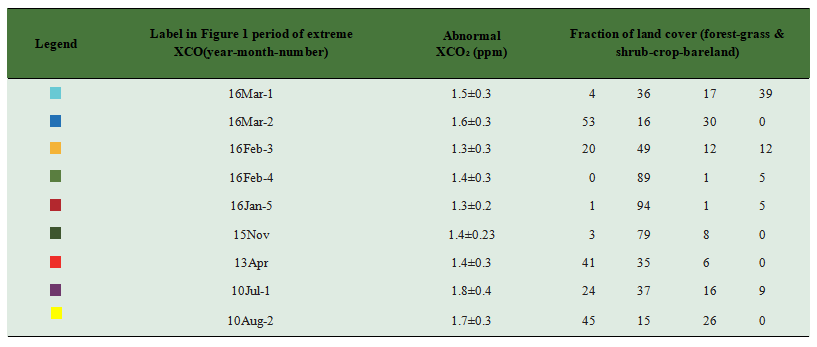
Both satellite observations and model simulations have shown an abnormal increase in global XCO2 during the summer of 2010, middle of 2013 and early 2016 that lasted for about 3 months (Figure 1). The largest anomaly of 10 ppm was detected in grasslands and forest areas (Figure 2, Table 1), with local abnormal XCO2 between 1.3 and 1.8 ppm. The period of XCO2 anomaly corresponds to the period of extreme weather events such as heat waves and extreme drought caused by El Nio or abnormal biomass burning in 2013. The interannual increase in global atmospheric CO2 concentrations during 2010, 2013, and 2016 are also higher than the average increase in the previous 10 years (2.3 ppm in 2010, 2.9 ppm in 2013, 3.3 ppm in 2016), while the anthropogenic carbon emissions in these periods did not exhibit any increasing trends. Particularly, in 2016 the concentration of CO2 reached 3.3 ppm, which also corresponds to the abnormal increase detected in satellite-observed XCO2 in several regions. It is shown from attribution analysis that abnormal XCO2 increase is associated with terrestrial ecological carbon emissions, influenced by extreme climate.

Figure 1. National Oceanic and Atmospheric Administration (NOAA) SOI (Southern Oscillation Index) (top), number of grids with extremely high XCO(Z-score>1.96) detected by satellite (GOSAT) and model (CarbonTracker) simulation for global land (bottom), and the ground-measured annual enhancement of CO2 from NOAA. Gray dashed lines are the time of detected regions with continuous extremely high XCO2 in space and time as shown in Figure 1.
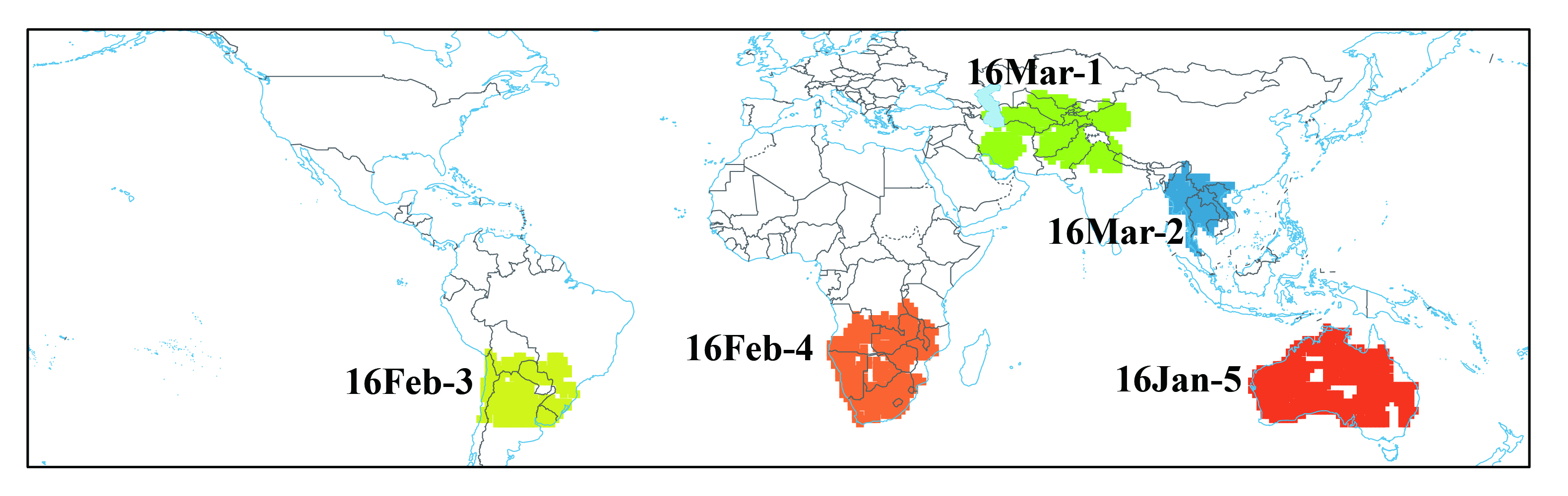
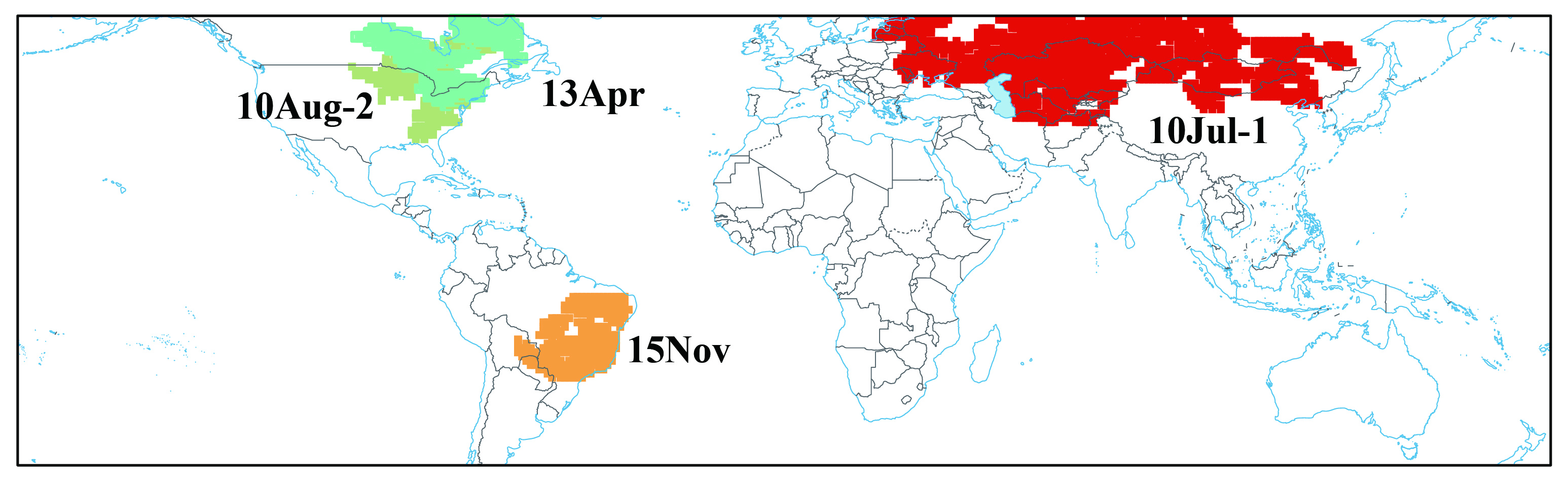
Figure 2. Location of extremely high XCO2 with the continuous grid in space and a time span detected by a flood-fill algorithm where the feature of each region is shown in Table 1.
Table 1. Characteristics of the extreme XCO2 regions as shown in Figure 1
| Highlights |
| Extreme climate change has enhanced CO2 emissions in some terrestrial ecological areas, which is consistent with the fluctuations of atmospheric CO2 data. While controlling human-made CO2 emissions, it is necessary to scientifically repair and manage sensitive terrestrial ecosystems in order to reduce the impact from extreme climate. |
Outlook
In the future, methods should be developed for GOSAT and OCO-2 observations to generate longer sequences of continuous spatiotemporal global atmospheric XCO2 (GM-XCO2). Spatiotemporal anomaly change detection methods could be applied to updated GM-XCO2 to detect extreme fluctuations in XCO2. Carbon-related datasets from remote sensing could be collected and used for analysis of terrestrial ecological carbon absorption characteristics in detected extremes. In the end, information on abnormal increases/decreases in XCO2 should be adopted for evaluating terrestrial ecological carbon source/sink change and sensitivity to extreme climate change.